|
|
|||||||||||||||||
| Point ID: 460 | Downloads | Plots | Site Data | Code: 05DC003 |
|
|
|||||||||||||||||
| Download | |
|---|---|
| Site Descriptor Information | Site Time Series Data |
| Link to all available data | |
|
|
| View: | Statistics | Time Series |
| Units: | m3/s |
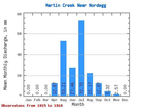
| Statistic | Jan | Feb | Mar | Apr | May | Jun | Jul | Aug | Sep | Oct | Nov | Dec | Annual |
|---|---|---|---|---|---|---|---|---|---|---|---|---|---|
| Mean | 0.00 | 0.00 | 0.30 | 12.45 | 52.76 | 27.46 | 73.01 | 21.87 | 12.59 | 5.03 | 3.00 | 0.00 | 176.35 |
| Standard Deviation | 0.00 | 0.00 | 0.51 | 9.10 | 19.44 | 6.07 | 71.90 | 22.30 | 13.63 | 5.70 | 1.82 | 0.00 | 58.50 |
| Min | 0.00 | 0.00 | 0.00 | 6.01 | 39.02 | 23.17 | 17.73 | 4.43 | 4.29 | 0.89 | 1.72 | 0.00 | 134.98 |
| Max | 0.00 | 0.00 | 0.89 | 18.88 | 66.51 | 31.76 | 154.29 | 47.00 | 28.32 | 11.53 | 4.29 | 0.00 | 217.72 |
| Coefficient of Variation | 1.73 | 0.73 | 0.37 | 0.22 | 0.98 | 1.02 | 1.08 | 1.14 | 0.61 | 0.33 |
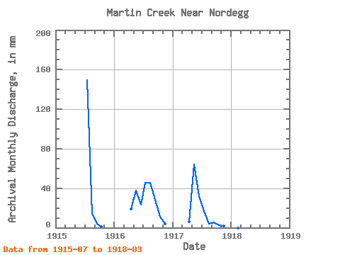
| Year | Jan | Feb | Mar | Apr | May | Jun | Jul | Aug | Sep | Oct | Nov | Dec | Annual | 1915 | 154.29 | 14.19 | 4.29 | 0.89 | 1916 | 0.00 | 0.00 | 0.00 | 18.88 | 39.02 | 23.17 | 47.00 | 47.00 | 28.32 | 11.53 | 4.29 | 0.00 | 217.72 | 1917 | 0.00 | 0.00 | 0.00 | 6.01 | 66.51 | 31.76 | 17.73 | 4.43 | 5.15 | 2.66 | 1.72 | 0.00 | 134.98 | 1918 | 0.00 | 0.00 | 0.89 |
|---|
 Return to R-Arctic Net Home Page