|
|
|||||||||||||||||
| Point ID: 448 | Downloads | Plots | Site Data | Code: 05DA008 |
|
|
|||||||||||||||||
| Download | |
|---|---|
| Site Descriptor Information | Site Time Series Data |
| Link to all available data | |
|
|
| View: | Statistics | Time Series |
| Units: | m3/s |
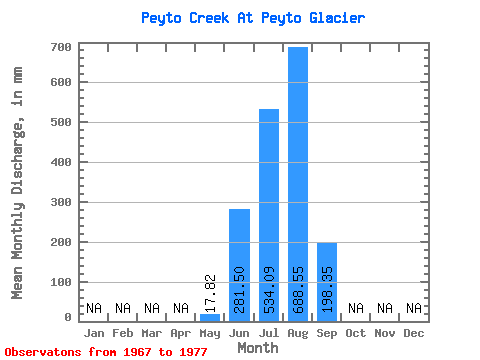
| Statistic | Jan | Feb | Mar | Apr | May | Jun | Jul | Aug | Sep | Oct | Nov | Dec | Annual |
|---|---|---|---|---|---|---|---|---|---|---|---|---|---|
| Mean | 17.82 | 281.50 | 534.01 | 688.41 | 198.37 | ||||||||
| Standard Deviation | 139.45 | 94.77 | 176.06 | 106.38 | |||||||||
| Min | 17.82 | 119.72 | 397.16 | 492.48 | 85.34 | ||||||||
| Max | 17.82 | 498.63 | 677.44 | 987.23 | 374.52 | ||||||||
| Coefficient of Variation | 0.49 | 0.18 | 0.26 | 0.54 |
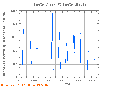
| Year | Jan | Feb | Mar | Apr | May | Jun | Jul | Aug | Sep | Oct | Nov | Dec | Annual | 1967 | 131.80 | 484.54 | 734.18 | 1968 | 576.45 | 492.48 | 205.38 | 1969 | 437.12 | 449.36 | 1970 | 498.63 | 1971 | 218.56 | 611.63 | 987.23 | 123.01 | 1972 | 17.82 | 389.90 | 544.68 | 697.87 | 141.68 | 1973 | 222.96 | 533.33 | 529.93 | 260.30 | 1974 | 393.19 | 642.27 | 688.79 | 374.52 | 1975 | 128.50 | 677.44 | 85.34 | 1976 | 119.72 | 397.16 | 1977 | 274.58 | 423.26 |
|---|
 Return to R-Arctic Net Home Page