|
|
|||||||||||||||||
| Point ID: 4435 | Downloads | Plots | Site Data | Code: 05QD001 |
|
|
|||||||||||||||||
| Download | |
|---|---|
| Site Descriptor Information | Site Time Series Data |
| Link to all available data | |
|
|
| View: | Statistics | Time Series |
| Units: | m3/s |
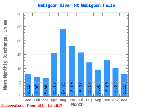
| Statistic | Jan | Feb | Mar | Apr | May | Jun | Jul | Aug | Sep | Oct | Nov | Dec | Annual |
|---|---|---|---|---|---|---|---|---|---|---|---|---|---|
| Mean | 8.12 | 7.04 | 6.66 | 15.62 | 24.11 | 18.09 | 15.74 | 12.21 | 9.66 | 13.09 | 10.27 | 8.15 | |
| Standard Deviation | 0.02 | 5.62 | 5.48 | 2.13 | 0.54 | ||||||||
| Min | 8.12 | 7.04 | 6.66 | 15.62 | 24.09 | 14.12 | 11.87 | 10.71 | 9.27 | 13.09 | 10.27 | 8.15 | |
| Max | 8.12 | 7.04 | 6.66 | 15.62 | 24.13 | 22.07 | 19.62 | 13.72 | 10.04 | 13.09 | 10.27 | 8.15 | |
| Coefficient of Variation | 0.00 | 0.31 | 0.35 | 0.17 | 0.06 |
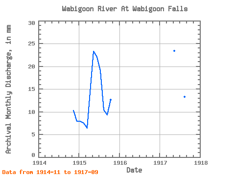
| Year | Jan | Feb | Mar | Apr | May | Jun | Jul | Aug | Sep | Oct | Nov | Dec | Annual | 1914 | 10.27 | 8.15 | 1915 | 8.12 | 7.04 | 6.66 | 15.62 | 24.09 | 22.07 | 19.62 | 10.71 | 9.27 | 13.09 | 1917 | 24.13 | 14.12 | 11.87 | 13.72 | 10.04 |
|---|
 Return to R-Arctic Net Home Page