|
|
|||||||||||||||||
| Point ID: 443 | Downloads | Plots | Site Data | Code: 05DA003 |
|
|
|||||||||||||||||
| Download | |
|---|---|
| Site Descriptor Information | Site Time Series Data |
| Link to all available data | |
|
|
| View: | Statistics | Time Series |
| Units: | m3/s |
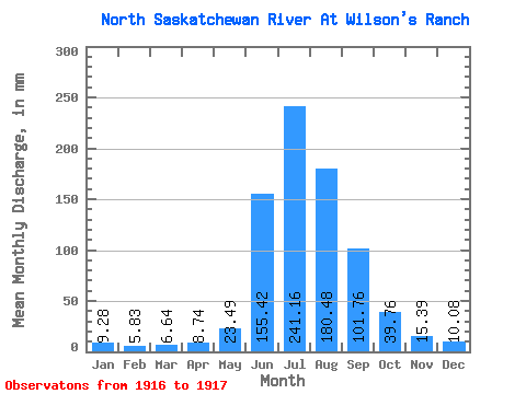
| Statistic | Jan | Feb | Mar | Apr | May | Jun | Jul | Aug | Sep | Oct | Nov | Dec | Annual |
|---|---|---|---|---|---|---|---|---|---|---|---|---|---|
| Mean | 9.28 | 5.88 | 6.64 | 8.74 | 23.48 | 155.42 | 241.12 | 180.45 | 101.76 | 39.75 | 15.39 | 10.07 | 830.96 |
| Standard Deviation | 1.20 | 0.51 | 1.55 | 4.53 | 5.55 | 65.15 | 11.10 | 14.05 | 0.72 | ||||
| Min | 8.43 | 5.52 | 5.54 | 5.54 | 19.56 | 109.35 | 233.28 | 170.51 | 101.25 | 39.75 | 15.39 | 10.07 | 830.96 |
| Max | 10.13 | 6.24 | 7.74 | 11.95 | 27.41 | 201.49 | 248.97 | 190.39 | 102.26 | 39.75 | 15.39 | 10.07 | 830.96 |
| Coefficient of Variation | 0.13 | 0.09 | 0.23 | 0.52 | 0.24 | 0.42 | 0.05 | 0.08 | 0.01 |
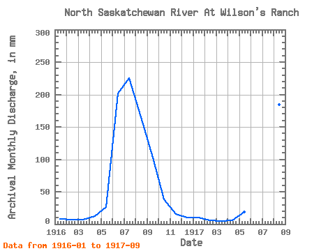
| Year | Jan | Feb | Mar | Apr | May | Jun | Jul | Aug | Sep | Oct | Nov | Dec | Annual | 1916 | 8.43 | 6.24 | 7.74 | 11.95 | 27.41 | 201.49 | 233.28 | 170.51 | 102.26 | 39.75 | 15.39 | 10.07 | 830.96 | 1917 | 10.13 | 5.52 | 5.54 | 5.54 | 19.56 | 109.35 | 248.97 | 190.39 | 101.25 |
|---|
 Return to R-Arctic Net Home Page