|
|
|||||||||||||||||
| Point ID: 4417 | Downloads | Plots | Site Data | Code: 05PD033 |
|
|
|||||||||||||||||
| Download | |
|---|---|
| Site Descriptor Information | Site Time Series Data |
| Link to all available data | |
|
|
| View: | Statistics | Time Series |
| Units: | m3/s |
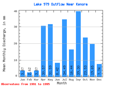
| Statistic | Jan | Feb | Mar | Apr | May | Jun | Jul | Aug | Sep | Oct | Nov | Dec | Annual |
|---|---|---|---|---|---|---|---|---|---|---|---|---|---|
| Mean | 3.76 | 2.64 | 3.87 | 30.41 | 31.66 | 8.50 | 34.56 | 16.36 | 39.38 | 23.36 | 19.65 | 7.65 | 254.67 |
| Standard Deviation | 4.05 | 3.39 | 3.87 | 21.44 | 37.61 | 9.29 | 24.32 | 15.02 | 35.43 | 15.26 | 18.16 | 5.98 | 90.12 |
| Min | 0.00 | 0.00 | 0.00 | 13.41 | 5.48 | 0.31 | 6.45 | 1.93 | 0.31 | 12.25 | 4.37 | 2.26 | 178.50 |
| Max | 8.06 | 6.46 | 7.73 | 61.76 | 86.69 | 20.27 | 65.74 | 37.06 | 77.36 | 45.44 | 40.86 | 16.11 | 354.15 |
| Coefficient of Variation | 1.08 | 1.28 | 1.00 | 0.70 | 1.19 | 1.09 | 0.70 | 0.92 | 0.90 | 0.65 | 0.92 | 0.78 | 0.35 |
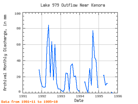
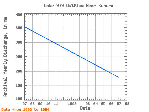
| Year | Jan | Feb | Mar | Apr | May | Jun | Jul | Aug | Sep | Oct | Nov | Dec | Annual | 1991 | 28.70 | 16.11 | 1992 | 8.06 | 6.46 | 7.73 | 61.76 | 86.69 | 20.27 | 65.74 | 16.43 | 59.89 | 12.25 | 4.68 | 5.16 | 354.15 | 1993 | 3.22 | 1.47 | 3.87 | 24.64 | 24.81 | 1.87 | 34.80 | 37.06 | 19.96 | 21.59 | 4.37 | 2.26 | 178.50 | 1994 | 0.00 | 0.00 | 0.00 | 13.41 | 5.48 | 0.31 | 31.26 | 9.99 | 77.36 | 45.44 | 40.86 | 7.09 | 231.35 | 1995 | 21.83 | 9.67 | 11.54 | 6.45 | 1.93 | 0.31 | 14.18 |
|---|
 Return to R-Arctic Net Home Page