|
|
|||||||||||||||||
| Point ID: 4414 | Downloads | Plots | Site Data | Code: 05PD028 |
|
|
|||||||||||||||||
| Download | |
|---|---|
| Site Descriptor Information | Site Time Series Data |
| Link to all available data | |
|
|
| View: | Statistics | Time Series |
| Units: | m3/s |
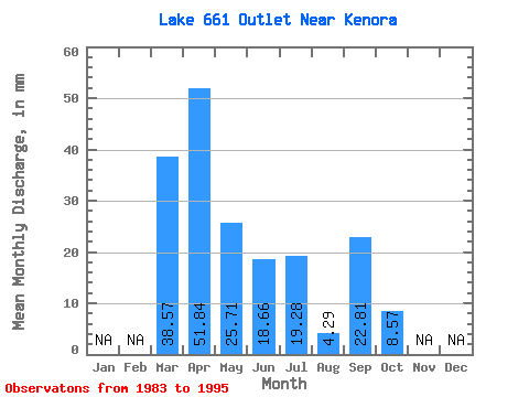
| Statistic | Jan | Feb | Mar | Apr | May | Jun | Jul | Aug | Sep | Oct | Nov | Dec | Annual |
|---|---|---|---|---|---|---|---|---|---|---|---|---|---|
| Mean | 38.56 | 52.70 | 26.24 | 17.97 | 18.21 | 4.64 | 23.67 | 7.68 | |||||
| Standard Deviation | 35.66 | 19.19 | 14.70 | 20.21 | 8.80 | 43.84 | 12.07 | ||||||
| Min | 38.56 | 6.22 | 4.29 | 0.00 | 0.00 | 0.00 | 0.00 | 0.00 | |||||
| Max | 38.56 | 118.19 | 64.27 | 39.40 | 59.99 | 29.99 | 134.78 | 34.28 | |||||
| Coefficient of Variation | 0.68 | 0.73 | 0.82 | 1.11 | 1.90 | 1.85 | 1.57 |
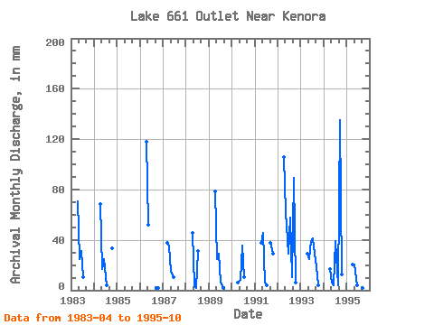
| Year | Jan | Feb | Mar | Apr | May | Jun | Jul | Aug | Sep | Oct | Nov | Dec | Annual | 1983 | 70.50 | 25.71 | 31.10 | 10.71 | 0.00 | 0.00 | 0.00 | 1984 | 68.43 | 17.14 | 24.88 | 4.29 | 0.00 | 0.00 | 34.28 | 1986 | 118.19 | 53.56 | 0.00 | 0.00 | 0.00 | 2.07 | 2.14 | 1987 | 38.56 | 35.25 | 15.00 | 10.37 | 0.00 | 0.00 | 0.00 | 0.00 | 1988 | 45.62 | 4.29 | 2.07 | 32.14 | 0.00 | 0.00 | 0.00 | 1989 | 78.80 | 25.71 | 29.03 | 6.43 | 2.14 | 0.00 | 0.00 | 1990 | 6.22 | 8.57 | 35.25 | 10.71 | 0.00 | 0.00 | 0.00 | 1991 | 37.33 | 47.13 | 6.22 | 4.29 | 0.00 | 37.33 | 29.99 | 1992 | 105.75 | 64.27 | 29.03 | 59.99 | 10.71 | 89.17 | 6.43 | 1993 | 29.03 | 25.71 | 39.40 | 42.85 | 29.99 | 18.66 | 4.29 | 1994 | 16.59 | 6.43 | 4.15 | 40.71 | 4.29 | 134.78 | 12.85 | 1995 | 20.74 | 21.42 | 4.15 | 6.43 | 8.57 | 2.07 | 2.14 |
|---|
 Return to R-Arctic Net Home Page