|
|
|||||||||||||||||
| Point ID: 4389 | Downloads | Plots | Site Data | Code: 05PB004 |
|
|
|||||||||||||||||
| Download | |
|---|---|
| Site Descriptor Information | Site Time Series Data |
| Link to all available data | |
|
|
| View: | Statistics | Time Series |
| Units: | m3/s |
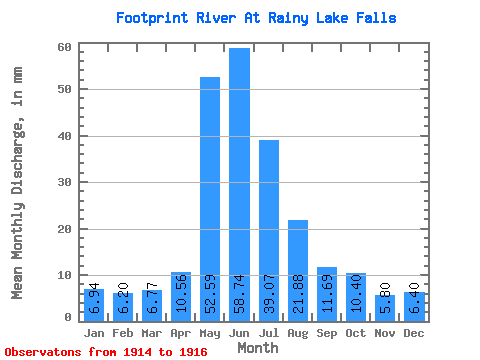
| Statistic | Jan | Feb | Mar | Apr | May | Jun | Jul | Aug | Sep | Oct | Nov | Dec | Annual |
|---|---|---|---|---|---|---|---|---|---|---|---|---|---|
| Mean | 6.94 | 6.26 | 6.77 | 10.56 | 52.58 | 58.74 | 39.06 | 21.88 | 11.69 | 10.40 | 5.80 | 6.40 | 188.23 |
| Standard Deviation | 1.65 | 1.41 | 0.54 | 6.89 | 30.92 | 17.82 | 3.13 | 0.96 | 3.65 | 5.69 | 0.57 | 0.89 | |
| Min | 5.77 | 5.26 | 6.39 | 5.68 | 30.71 | 46.13 | 36.85 | 21.20 | 9.11 | 5.38 | 5.40 | 5.77 | 188.23 |
| Max | 8.11 | 7.25 | 7.15 | 15.43 | 74.44 | 71.34 | 41.28 | 22.55 | 14.27 | 16.58 | 6.21 | 7.03 | 188.23 |
| Coefficient of Variation | 0.24 | 0.23 | 0.08 | 0.65 | 0.59 | 0.30 | 0.08 | 0.04 | 0.31 | 0.55 | 0.10 | 0.14 |
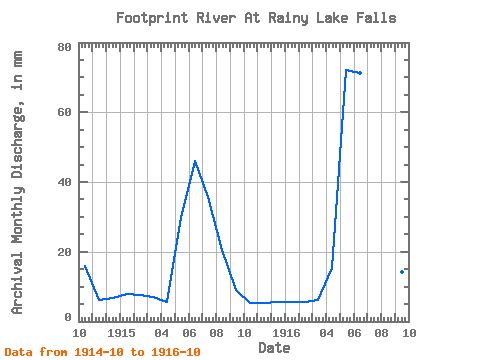
| Year | Jan | Feb | Mar | Apr | May | Jun | Jul | Aug | Sep | Oct | Nov | Dec | Annual | 1914 | 16.58 | 6.21 | 7.03 | 1915 | 8.11 | 7.25 | 7.15 | 5.68 | 30.71 | 46.13 | 36.85 | 21.20 | 9.11 | 5.38 | 5.40 | 5.77 | 188.23 | 1916 | 5.77 | 5.26 | 6.39 | 15.43 | 74.44 | 71.34 | 41.28 | 22.55 | 14.27 | 9.24 |
|---|
 Return to R-Arctic Net Home Page