|
|
|||||||||||||||||
| Point ID: 3691 | Downloads | Plots | Site Data | Code: 10UB001 |
|
|
|||||||||||||||||
| Download | |
|---|---|
| Site Descriptor Information | Site Time Series Data |
| Link to all available data | |
|
|
| View: | Statistics | Time Series |
| Units: | m3/s |
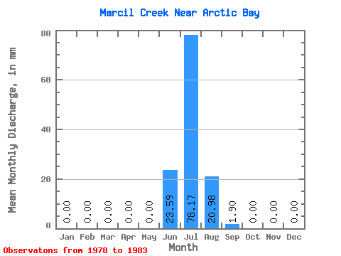
| Statistic | Jan | Feb | Mar | Apr | May | Jun | Jul | Aug | Sep | Oct | Nov | Dec | Annual |
|---|---|---|---|---|---|---|---|---|---|---|---|---|---|
| Mean | 0.00 | 0.00 | 0.00 | 0.00 | 0.00 | 23.59 | 78.16 | 20.99 | 1.90 | 0.00 | 0.00 | 0.00 | 123.23 |
| Standard Deviation | 0.00 | 0.00 | 0.00 | 0.00 | 0.00 | 23.82 | 32.87 | 11.90 | 1.18 | 0.00 | 0.00 | 0.00 | 16.00 |
| Min | 0.00 | 0.00 | 0.00 | 0.00 | 0.00 | 2.83 | 46.05 | 10.48 | 0.60 | 0.00 | 0.00 | 0.00 | 104.82 |
| Max | 0.00 | 0.00 | 0.00 | 0.00 | 0.00 | 49.60 | 111.74 | 33.91 | 2.89 | 0.00 | 0.00 | 0.00 | 133.79 |
| Coefficient of Variation | 1.01 | 0.42 | 0.57 | 0.62 | 0.13 |
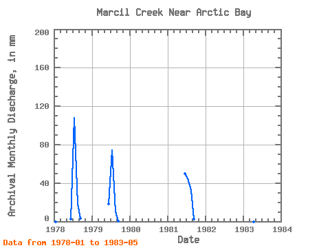
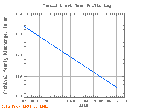
| Year | Jan | Feb | Mar | Apr | May | Jun | Jul | Aug | Sep | Oct | Nov | Dec | Annual | 1978 | 0.00 | 0.00 | 0.00 | 0.00 | 0.00 | 2.83 | 111.74 | 18.57 | 2.89 | 0.00 | 0.00 | 0.00 | 133.79 | 1979 | 0.00 | 0.00 | 0.00 | 0.00 | 0.00 | 18.35 | 76.68 | 10.48 | 0.60 | 0.00 | 0.00 | 0.00 | 104.82 | 1981 | 0.00 | 0.00 | 0.00 | 0.00 | 0.00 | 49.60 | 46.05 | 33.91 | 2.20 | 0.00 | 0.00 | 0.00 | 131.08 | 1982 | 0.00 | 0.00 | 0.00 | 0.00 | 1983 | 0.00 |
|---|
 Return to R-Arctic Net Home Page