|
|
|||||||||||||||||
| Point ID: 3677 | Downloads | Plots | Site Data | Code: 10PC002 |
|
|
|||||||||||||||||
| Download | |
|---|---|
| Site Descriptor Information | Site Time Series Data |
| Link to all available data | |
|
|
| View: | Statistics | Time Series |
| Units: | m3/s |
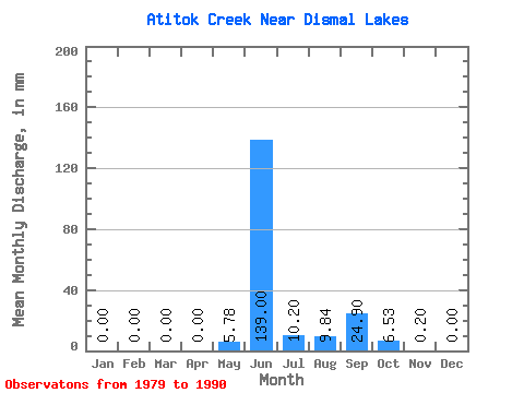
| Statistic | Jan | Feb | Mar | Apr | May | Jun | Jul | Aug | Sep | Oct | Nov | Dec | Annual |
|---|---|---|---|---|---|---|---|---|---|---|---|---|---|
| Mean | 0.00 | 0.00 | 0.00 | 0.00 | 5.78 | 139.01 | 10.19 | 9.84 | 24.91 | 6.53 | 0.20 | 0.00 | 197.76 |
| Standard Deviation | 0.00 | 0.00 | 0.00 | 0.00 | 15.00 | 53.95 | 7.69 | 9.04 | 29.21 | 12.42 | 0.48 | 0.00 | 84.90 |
| Min | 0.00 | 0.00 | 0.00 | 0.00 | 0.00 | 67.25 | 1.90 | 1.43 | 1.67 | 0.30 | 0.00 | 0.00 | 106.87 |
| Max | 0.00 | 0.00 | 0.00 | 0.00 | 42.82 | 222.17 | 26.66 | 26.29 | 90.18 | 40.11 | 1.39 | 0.00 | 322.48 |
| Coefficient of Variation | 2.59 | 0.39 | 0.75 | 0.92 | 1.17 | 1.90 | 2.43 | 0.43 |
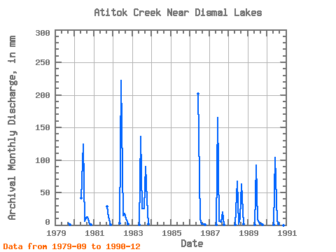
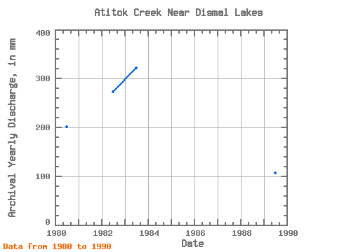
| Year | Jan | Feb | Mar | Apr | May | Jun | Jul | Aug | Sep | Oct | Nov | Dec | Annual | 1979 | 2.79 | 0.59 | 0.00 | 0.00 | 1980 | 0.00 | 0.00 | 0.00 | 0.00 | 42.82 | 124.22 | 6.64 | 12.03 | 12.66 | 1.65 | 0.10 | 0.00 | 201.01 | 1981 | 28.55 | 13.33 | 0.11 | 0.00 | 1982 | 0.00 | 0.00 | 0.00 | 0.00 | 2.84 | 222.17 | 15.55 | 18.27 | 10.67 | 1.43 | 0.00 | 0.00 | 273.65 | 1983 | 0.00 | 0.00 | 0.00 | 0.00 | 0.03 | 136.17 | 26.66 | 26.29 | 90.18 | 40.11 | 1.39 | 0.00 | 322.48 | 1986 | 0.00 | 201.87 | 9.65 | 1.91 | 1.67 | 0.30 | 1987 | 0.00 | 0.00 | 0.00 | 0.00 | 0.07 | 164.84 | 6.27 | 4.84 | 19.71 | 1.10 | 1988 | 0.00 | 0.00 | 0.00 | 0.00 | 0.03 | 67.25 | 1.90 | 12.02 | 62.83 | 1.75 | 0.00 | 0.00 | 147.40 | 1989 | 0.00 | 0.00 | 0.00 | 0.00 | 0.06 | 92.21 | 8.28 | 1.94 | 2.46 | 0.73 | 0.00 | 0.00 | 106.87 | 1990 | 0.00 | 0.00 | 0.00 | 0.00 | 0.40 | 103.32 | 6.58 | 1.43 | 17.56 | 4.32 | 0.00 | 0.00 | 135.15 |
|---|
 Return to R-Arctic Net Home Page