|
|
|||||||||||||||||
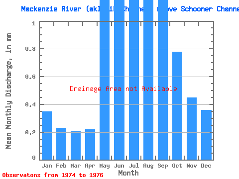
| Point ID: 3665 | Downloads | Plots | Site Data | Code: 10MC005 |
|
|
|||||||||||||||||
| Download | |
|---|---|
| Site Descriptor Information | Site Time Series Data |
| Link to all available data | |
|
|
| View: | Statistics | Time Series |
| Units: | m3/s |
| Statistic | Jan | Feb | Mar | Apr | May | Jun | Jul | Aug | Sep | Oct | Nov | Dec | Annual |
|---|---|---|---|---|---|---|---|---|---|---|---|---|---|
| Mean | |||||||||||||
| Standard Deviation | |||||||||||||
| Min | |||||||||||||
| Max | |||||||||||||
| Coefficient of Variation | 0.16 | 0.29 | 0.18 | 0.18 | 0.30 | 0.08 | 0.05 | 0.20 | 0.06 | 0.15 | 0.27 | 0.33 | 0.01 |
| Year | Jan | Feb | Mar | Apr | May | Jun | Jul | Aug | Sep | Oct | Nov | Dec | Annual | 1974 | 1975 | 1976 |
|---|
 Return to R-Arctic Net Home Page