|
|
|||||||||||||||||
| Point ID: 3644 | Downloads | Plots | Site Data | Code: 10KA005 |
|
|
|||||||||||||||||
| Download | |
|---|---|
| Site Descriptor Information | Site Time Series Data |
| Link to all available data | |
|
|
| View: | Statistics | Time Series |
| Units: | m3/s |
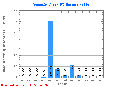
| Statistic | Jan | Feb | Mar | Apr | May | Jun | Jul | Aug | Sep | Oct | Nov | Dec | Annual |
|---|---|---|---|---|---|---|---|---|---|---|---|---|---|
| Mean | 0.00 | 0.00 | 0.00 | 0.82 | 50.32 | 7.81 | 2.59 | 11.64 | 2.56 | 0.02 | 0.00 | 0.00 | 59.52 |
| Standard Deviation | 0.00 | 0.00 | 0.00 | 1.38 | 51.34 | 4.66 | 3.25 | 25.88 | 5.63 | 0.04 | 0.00 | 0.00 | 50.41 |
| Min | 0.00 | 0.00 | 0.00 | 0.00 | 2.09 | 1.18 | 0.09 | 0.00 | 0.00 | 0.00 | 0.00 | 0.00 | 14.09 |
| Max | 0.00 | 0.00 | 0.00 | 2.86 | 122.64 | 11.95 | 8.00 | 57.93 | 12.63 | 0.09 | 0.00 | 0.00 | 131.63 |
| Coefficient of Variation | 1.68 | 1.02 | 0.60 | 1.25 | 2.22 | 2.20 | 2.00 | 0.85 |
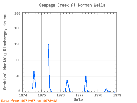
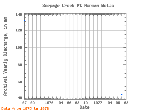
| Year | Jan | Feb | Mar | Apr | May | Jun | Jul | Aug | Sep | Oct | Nov | Dec | Annual | 1974 | 8.00 | 57.93 | 12.63 | 1975 | 0.00 | 0.00 | 0.00 | 0.00 | 122.64 | 9.77 | 1.30 | 0.00 | 0.00 | 0.00 | 0.00 | 0.00 | 131.63 | 1976 | 0.00 | 0.00 | 0.00 | 2.86 | 32.79 | 11.95 | 0.43 | 0.00 | 0.00 | 0.00 | 0.00 | 0.00 | 47.66 | 1977 | 0.00 | 0.00 | 0.00 | 0.42 | 43.75 | 1.18 | 0.09 | 0.00 | 0.00 | 0.00 | 0.00 | 0.00 | 44.67 | 1978 | 0.00 | 0.00 | 0.00 | 0.00 | 2.09 | 8.33 | 3.13 | 0.26 | 0.17 | 0.09 | 0.00 | 0.00 | 14.09 |
|---|
 Return to R-Arctic Net Home Page