|
|
|||||||||||||||||
| Point ID: 3643 | Downloads | Plots | Site Data | Code: 10KA003 |
|
|
|||||||||||||||||
| Download | |
|---|---|
| Site Descriptor Information | Site Time Series Data |
| Link to all available data | |
|
|
| View: | Statistics | Time Series |
| Units: | m3/s |
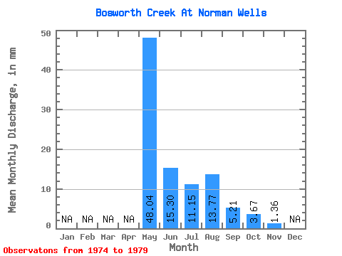
| Statistic | Jan | Feb | Mar | Apr | May | Jun | Jul | Aug | Sep | Oct | Nov | Dec | Annual |
|---|---|---|---|---|---|---|---|---|---|---|---|---|---|
| Mean | 48.02 | 15.30 | 11.16 | 13.77 | 5.21 | 3.67 | 1.36 | ||||||
| Standard Deviation | 17.59 | 9.35 | 7.05 | 20.56 | 1.62 | 1.02 | |||||||
| Min | 23.93 | 7.50 | 5.27 | 3.12 | 2.51 | 2.94 | 1.36 | ||||||
| Max | 66.07 | 28.89 | 23.27 | 55.54 | 6.50 | 4.39 | 1.36 | ||||||
| Coefficient of Variation | 0.37 | 0.61 | 0.63 | 1.49 | 0.31 | 0.28 |
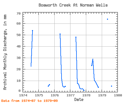
| Year | Jan | Feb | Mar | Apr | May | Jun | Jul | Aug | Sep | Oct | Nov | Dec | Annual | 1974 | 23.27 | 55.54 | 1975 | 5.31 | 6.50 | 1976 | 52.46 | 12.20 | 5.27 | 4.24 | 5.01 | 1977 | 49.61 | 7.50 | 7.42 | 3.12 | 2.51 | 2.94 | 1.36 | 1978 | 23.93 | 28.89 | 10.40 | 9.07 | 6.33 | 4.39 | 1979 | 66.07 | 12.62 | 9.44 | 5.33 | 5.69 |
|---|
 Return to R-Arctic Net Home Page