|
|
|||||||||||||||||
| Point ID: 3633 | Downloads | Plots | Site Data | Code: 10HC005 |
|
|
|||||||||||||||||
| Download | |
|---|---|
| Site Descriptor Information | Site Time Series Data |
| Link to all available data | |

|

|
| View: | Statistics | Time Series |
| Units: | m3/s |
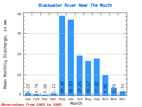
| Statistic | Jan | Feb | Mar | Apr | May | Jun | Jul | Aug | Sep | Oct | Nov | Dec | Annual |
|---|---|---|---|---|---|---|---|---|---|---|---|---|---|
| Mean | 1.23 | 0.74 | 0.56 | 1.11 | 38.47 | 36.59 | 19.26 | 16.67 | 17.82 | 9.92 | 3.76 | 1.91 | 163.15 |
| Standard Deviation | 1.16 | 0.59 | 0.51 | 0.50 | 23.16 | 22.37 | 2.82 | 14.08 | 19.77 | 10.18 | 4.21 | 1.88 | 1.09 |
| Min | 0.41 | 0.33 | 0.19 | 0.76 | 22.09 | 11.31 | 16.07 | 6.33 | 3.51 | 2.18 | 0.96 | 0.46 | 162.38 |
| Max | 2.05 | 1.16 | 0.92 | 1.46 | 54.85 | 53.83 | 21.42 | 32.70 | 40.38 | 21.45 | 8.60 | 4.04 | 163.92 |
| Coefficient of Variation | 0.94 | 0.79 | 0.92 | 0.45 | 0.60 | 0.61 | 0.15 | 0.84 | 1.11 | 1.03 | 1.12 | 0.98 | 0.01 |
| Year | Jan | Feb | Mar | Apr | May | Jun | Jul | Aug | Sep | Oct | Nov | Dec | Annual | 1983 | 44.61 | 16.07 | 6.33 | 3.51 | 2.18 | 0.96 | 0.46 | 1984 | 0.41 | 0.33 | 0.19 | 1.46 | 22.09 | 11.31 | 20.29 | 32.70 | 40.38 | 21.45 | 8.60 | 4.04 | 162.38 | 1985 | 2.05 | 1.16 | 0.92 | 0.76 | 54.85 | 53.83 | 21.42 | 10.97 | 9.57 | 6.13 | 1.72 | 1.23 | 163.92 |
|---|
 Return to R-Arctic Net Home Page