|
|
|||||||||||||||||
| Point ID: 3585 | Downloads | Plots | Site Data | Other Close Sites | Code: 07SB006 |
|
|
|||||||||||||||||
| Download | |
|---|---|
| Site Descriptor Information | Site Time Series Data |
| Link to all available data | |
|
|
| View: | Statistics | Time Series |
| Units: | m3/s |
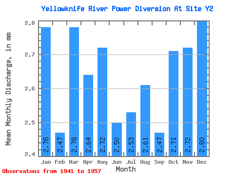
| Statistic | Jan | Feb | Mar | Apr | May | Jun | Jul | Aug | Sep | Oct | Nov | Dec | Annual |
|---|---|---|---|---|---|---|---|---|---|---|---|---|---|
| Mean | 2.78 | 2.49 | 2.78 | 2.64 | 2.72 | 2.50 | 2.53 | 2.60 | 2.47 | 2.71 | 2.72 | 2.80 | 31.80 |
| Standard Deviation | 0.29 | 0.30 | 0.30 | 0.31 | 0.41 | 0.54 | 0.60 | 0.55 | 0.68 | 0.42 | 0.33 | 0.28 | 4.51 |
| Min | 2.25 | 1.93 | 2.17 | 1.95 | 1.81 | 1.40 | 1.27 | 1.38 | 0.58 | 1.82 | 2.01 | 2.27 | 22.47 |
| Max | 3.07 | 2.80 | 3.10 | 2.97 | 3.07 | 2.97 | 3.05 | 3.07 | 3.00 | 3.10 | 3.00 | 3.07 | 36.02 |
| Coefficient of Variation | 0.11 | 0.12 | 0.11 | 0.12 | 0.15 | 0.22 | 0.24 | 0.21 | 0.28 | 0.15 | 0.12 | 0.10 | 0.14 |
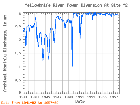
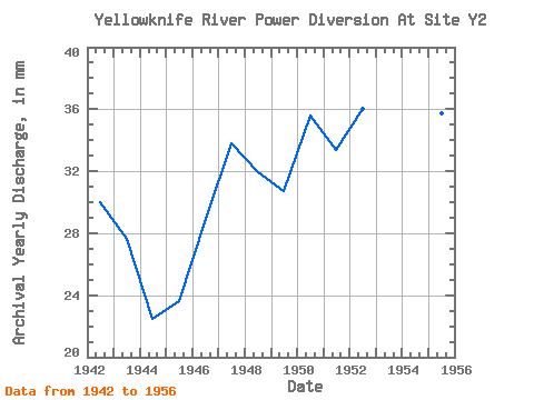
| Year | Jan | Feb | Mar | Apr | May | Jun | Jul | Aug | Sep | Oct | Nov | Dec | Annual | 1941 | 2.17 | 2.48 | 2.40 | 2.34 | 1.99 | 1.76 | 2.24 | 2.47 | 2.56 | 2.47 | 2.58 | 1942 | 2.63 | 2.21 | 2.38 | 2.54 | 2.60 | 2.47 | 2.53 | 2.58 | 2.43 | 2.63 | 2.50 | 2.51 | 30.00 | 1943 | 2.65 | 2.46 | 2.90 | 2.73 | 2.68 | 2.04 | 2.21 | 2.06 | 1.73 | 1.82 | 2.01 | 2.30 | 27.64 | 1944 | 2.27 | 2.13 | 2.31 | 1.95 | 1.81 | 1.40 | 1.27 | 1.38 | 1.58 | 1.95 | 2.11 | 2.27 | 22.47 | 1945 | 2.25 | 2.01 | 2.17 | 2.09 | 1.89 | 1.44 | 1.31 | 1.44 | 1.83 | 2.25 | 2.43 | 2.48 | 23.61 | 1946 | 2.51 | 2.28 | 2.48 | 2.36 | 2.36 | 1.97 | 1.96 | 2.17 | 2.33 | 2.75 | 2.83 | 2.90 | 28.92 | 1947 | 2.92 | 2.69 | 2.97 | 2.76 | 2.88 | 2.76 | 2.83 | 2.90 | 2.78 | 2.80 | 2.76 | 2.80 | 33.85 | 1948 | 2.75 | 2.53 | 2.78 | 2.64 | 2.56 | 2.40 | 2.58 | 2.70 | 2.62 | 2.83 | 2.66 | 2.85 | 31.90 | 1949 | 2.85 | 2.57 | 2.80 | 2.62 | 2.78 | 2.59 | 2.73 | 2.78 | 0.58 | 2.38 | 2.97 | 3.07 | 30.70 | 1950 | 3.05 | 2.78 | 3.10 | 2.97 | 3.07 | 2.95 | 2.95 | 2.92 | 2.92 | 3.07 | 2.97 | 2.90 | 35.66 | 1951 | 2.39 | 1.93 | 2.68 | 2.47 | 2.97 | 2.92 | 2.95 | 3.05 | 2.97 | 3.07 | 2.97 | 3.07 | 33.40 | 1952 | 3.07 | 2.78 | 3.05 | 2.92 | 3.07 | 2.95 | 3.00 | 3.07 | 2.95 | 3.10 | 3.00 | 3.07 | 36.02 | 1953 | 3.05 | 2.80 | 3.07 | 2.73 | 3.07 | 2.97 | 2.92 | 2.97 | 3.00 | 3.02 | 3.00 | 2.97 | 35.59 | 1954 | 3.02 | 2.78 | 3.05 | 2.95 | 3.05 | 2.95 | 3.05 | 3.00 | 2.97 | 3.07 | 2.97 | 3.05 | 35.90 | 1955 | 3.02 | 2.75 | 3.02 | 2.92 | 3.05 | 2.92 | 2.97 | 3.05 | 2.95 | 3.07 | 2.97 | 3.05 | 35.76 | 1956 | 3.02 | 2.75 | 3.02 | 2.95 | 3.02 | 2.92 | 2.97 | 2.95 | 2.92 | 3.05 | 2.95 | 3.00 | 35.54 | 1957 | 3.02 | 2.73 | 3.00 | 2.92 | 3.02 | 2.88 | 2.97 | 3.02 | 2.95 |
|---|
| Other Close Sites | ||||||
|---|---|---|---|---|---|---|
| PointID | Latitude | Longitude | Drainage Area | Source | Name | |
| 3581 | "YELLOWKNIFE RIVER AT OUTLET FROM PROSPEROUS LAKE" | 62.54 | 1237837 | Hydat | ||
| 3582 | "YELLOWKNIFE RIVER AT INLET TO PROSPEROUS LAKE" | 62.67 | 1236881 | Hydat | ||
 Return to R-Arctic Net Home Page