|
|
|||||||||||||||||
| Point ID: 3570 | Downloads | Plots | Site Data | Code: 07QD003 |
|
|
|||||||||||||||||
| Download | |
|---|---|
| Site Descriptor Information | Site Time Series Data |
| Link to all available data | |
|
|
| View: | Statistics | Time Series |
| Units: | m3/s |
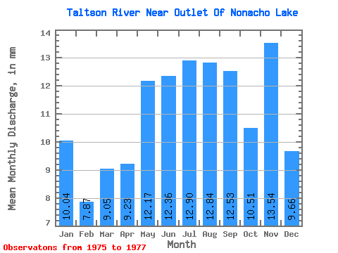
| Statistic | Jan | Feb | Mar | Apr | May | Jun | Jul | Aug | Sep | Oct | Nov | Dec | Annual |
|---|---|---|---|---|---|---|---|---|---|---|---|---|---|
| Mean | 10.04 | 7.94 | 9.05 | 9.23 | 12.17 | 12.36 | 12.90 | 12.84 | 12.53 | 10.51 | 13.54 | 9.66 | 127.99 |
| Standard Deviation | 3.39 | 2.27 | 1.38 | 1.31 | 3.57 | 5.07 | 5.89 | 2.46 | 2.70 | 0.20 | 5.39 | 0.92 | 24.42 |
| Min | 7.64 | 6.33 | 8.07 | 8.30 | 9.65 | 8.77 | 8.73 | 11.10 | 10.52 | 10.37 | 9.84 | 9.01 | 110.72 |
| Max | 12.44 | 9.54 | 10.03 | 10.15 | 14.69 | 15.94 | 17.06 | 14.57 | 15.60 | 10.65 | 19.73 | 10.31 | 145.25 |
| Coefficient of Variation | 0.34 | 0.29 | 0.15 | 0.14 | 0.29 | 0.41 | 0.46 | 0.19 | 0.22 | 0.02 | 0.40 | 0.10 | 0.19 |
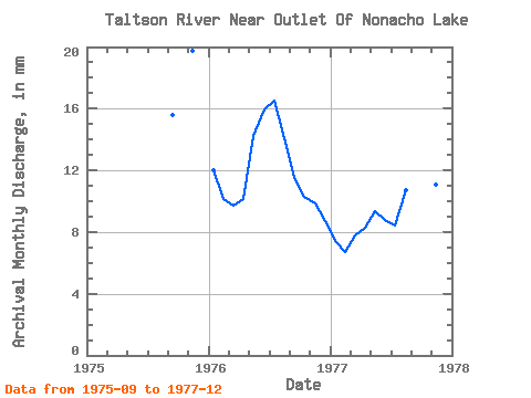
| Year | Jan | Feb | Mar | Apr | May | Jun | Jul | Aug | Sep | Oct | Nov | Dec | Annual | 1975 | 15.60 | 19.73 | 1976 | 12.44 | 9.54 | 10.03 | 10.15 | 14.69 | 15.94 | 17.06 | 14.57 | 11.47 | 10.65 | 9.84 | 9.01 | 145.25 | 1977 | 7.64 | 6.33 | 8.07 | 8.30 | 9.65 | 8.77 | 8.73 | 11.10 | 10.52 | 10.37 | 11.04 | 10.31 | 110.72 |
|---|
 Return to R-Arctic Net Home Page