|
|
|||||||||||||||||
| Point ID: 3552 | Downloads | Plots | Site Data | Code: 06PA001 |
|
|
|||||||||||||||||
| Download | |
|---|---|
| Site Descriptor Information | Site Time Series Data |
| Link to all available data | |
|
|
| View: | Statistics | Time Series |
| Units: | m3/s |
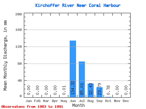
| Statistic | Jan | Feb | Mar | Apr | May | Jun | Jul | Aug | Sep | Oct | Nov | Dec | Annual |
|---|---|---|---|---|---|---|---|---|---|---|---|---|---|
| Mean | 0.00 | 0.00 | 0.00 | 0.00 | 0.01 | 134.32 | 85.00 | 32.42 | 23.79 | 0.78 | 0.00 | 0.00 | 257.31 |
| Standard Deviation | 0.00 | 0.00 | 0.00 | 0.00 | 0.02 | 45.74 | 48.00 | 19.07 | 16.58 | 0.94 | 0.00 | 0.00 | 79.29 |
| Min | 0.00 | 0.00 | 0.00 | 0.00 | 0.00 | 100.07 | 31.19 | 10.34 | 5.69 | 0.10 | 0.00 | 0.00 | 188.17 |
| Max | 0.00 | 0.00 | 0.00 | 0.00 | 0.04 | 201.78 | 157.63 | 60.85 | 49.30 | 2.27 | 0.01 | 0.00 | 343.86 |
| Coefficient of Variation | 2.00 | 0.34 | 0.56 | 0.59 | 0.70 | 1.21 | 2.24 | 0.31 |
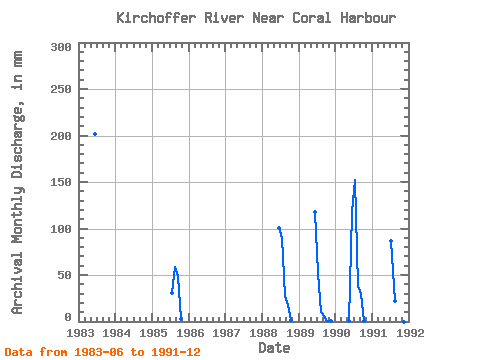
| Year | Jan | Feb | Mar | Apr | May | Jun | Jul | Aug | Sep | Oct | Nov | Dec | Annual | 1983 | 201.78 | 1985 | 0.00 | 31.19 | 60.85 | 49.30 | 2.27 | 0.00 | 0.00 | 1988 | 0.00 | 0.00 | 0.00 | 0.00 | 0.00 | 100.07 | 93.22 | 28.39 | 17.55 | 1.13 | 0.00 | 0.00 | 239.89 | 1989 | 0.00 | 0.00 | 0.00 | 0.00 | 0.00 | 117.30 | 53.98 | 10.34 | 5.69 | 0.21 | 0.01 | 0.00 | 188.17 | 1990 | 0.00 | 0.00 | 0.00 | 0.00 | 0.04 | 118.12 | 157.63 | 39.66 | 29.61 | 0.17 | 0.00 | 0.00 | 343.86 | 1991 | 88.98 | 22.88 | 16.82 | 0.10 | 0.00 | 0.00 |
|---|
 Return to R-Arctic Net Home Page