|
|
|||||||||||||||||
| Point ID: 3548 | Downloads | Plots | Site Data | Code: 06OA003 |
|
|
|||||||||||||||||
| Download | |
|---|---|
| Site Descriptor Information | Site Time Series Data |
| Link to all available data | |
|
|
| View: | Statistics | Time Series |
| Units: | m3/s |
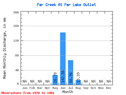
| Statistic | Jan | Feb | Mar | Apr | May | Jun | Jul | Aug | Sep | Oct | Nov | Dec | Annual |
|---|---|---|---|---|---|---|---|---|---|---|---|---|---|
| Mean | 26.78 | 145.80 | 70.30 | 13.39 | |||||||||
| Standard Deviation | 77.31 | 57.20 | 26.78 | ||||||||||
| Min | 26.78 | 90.72 | 0.00 | 0.00 | |||||||||
| Max | 26.78 | 259.20 | 133.90 | 53.56 | |||||||||
| Coefficient of Variation | 0.53 | 0.81 | 2.00 |
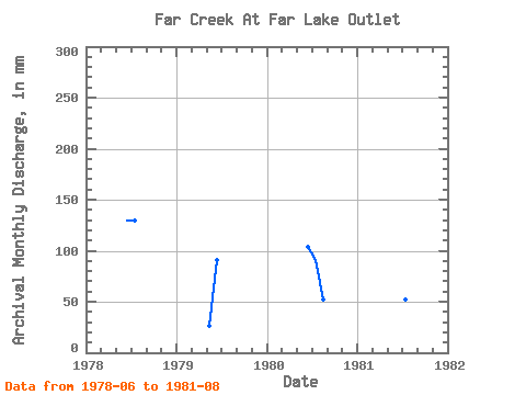
| Year | Jan | Feb | Mar | Apr | May | Jun | Jul | Aug | Sep | Oct | Nov | Dec | Annual | 1978 | 129.60 | 133.90 | 0.00 | 1979 | 26.78 | 90.72 | 0.00 | 0.00 | 1980 | 103.68 | 93.73 | 53.56 | 1981 | 259.20 | 53.56 | 0.00 |
|---|
 Return to R-Arctic Net Home Page