|
|
|||||||||||||||||
| Point ID: 3531 | Downloads | Plots | Site Data | Other Close Sites | Code: 06KC001 |
|
|
|||||||||||||||||
| Download | |
|---|---|
| Site Descriptor Information | Site Time Series Data |
| Link to all available data | |
|
|
| View: | Statistics | Time Series |
| Units: | m3/s |
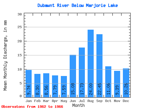
| Statistic | Jan | Feb | Mar | Apr | May | Jun | Jul | Aug | Sep | Oct | Nov | Dec | Annual |
|---|---|---|---|---|---|---|---|---|---|---|---|---|---|
| Mean | 9.74 | 8.37 | 8.56 | 7.79 | 7.59 | 15.08 | 17.73 | 23.99 | 22.45 | 11.06 | 9.39 | 10.25 | 133.32 |
| Standard Deviation | 0.28 | 0.56 | 0.95 | 1.13 | 1.42 | 4.59 | 2.48 | 12.96 | 14.03 | 1.03 | 1.57 | 0.00 | |
| Min | 9.54 | 7.98 | 7.89 | 6.99 | 6.59 | 11.83 | 15.97 | 15.03 | 12.94 | 10.33 | 8.28 | 10.25 | 133.32 |
| Max | 9.94 | 8.77 | 9.23 | 8.59 | 8.60 | 18.32 | 19.48 | 38.85 | 38.56 | 11.79 | 10.50 | 10.25 | 133.32 |
| Coefficient of Variation | 0.03 | 0.07 | 0.11 | 0.15 | 0.19 | 0.30 | 0.14 | 0.54 | 0.62 | 0.09 | 0.17 | 0.00 |
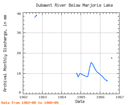
| Year | Jan | Feb | Mar | Apr | May | Jun | Jul | Aug | Sep | Oct | Nov | Dec | Annual | 1962 | 38.85 | 38.56 | 1964 | 10.33 | 8.28 | 10.25 | 1965 | 9.94 | 8.77 | 9.23 | 8.59 | 8.60 | 11.83 | 15.97 | 15.03 | 12.94 | 11.79 | 10.50 | 10.25 | 133.32 | 1966 | 9.54 | 7.98 | 7.89 | 6.99 | 6.59 | 18.32 | 19.48 | 18.10 | 15.84 |
|---|
| Other Close Sites | ||||||
|---|---|---|---|---|---|---|
| PointID | Latitude | Longitude | Drainage Area | Source | Name | |
| 3532 | "DUBAWNT RIVER AT OUTLET OF MARJORIE LAKE" | 64.26 | 472843 | Hydat | ||
 Return to R-Arctic Net Home Page