|
|
|||||||||||||||||
| Point ID: 302 | Downloads | Plots | Site Data | Code: 05BK003 |
|
|
|||||||||||||||||
| Download | |
|---|---|
| Site Descriptor Information | Site Time Series Data |
| Link to all available data | |
|
|
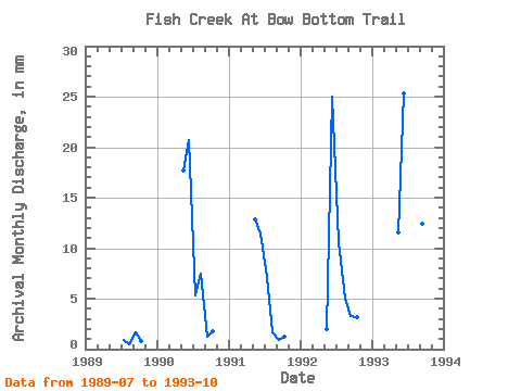
| View: | Statistics | Time Series |
| Units: | m3/s |
| Statistic | Jan | Feb | Mar | Apr | May | Jun | Jul | Aug | Sep | Oct | Nov | Dec | Annual |
|---|---|---|---|---|---|---|---|---|---|---|---|---|---|
| Mean | 11.26 | 20.39 | 8.76 | 6.67 | 3.87 | 2.74 | |||||||
| Standard Deviation | 6.71 | 6.40 | 6.92 | 7.14 | 4.78 | 2.25 | |||||||
| Min | 2.04 | 11.32 | 0.89 | 0.50 | 0.89 | 0.88 | |||||||
| Max | 18.05 | 25.04 | 19.33 | 18.42 | 12.26 | 6.42 | |||||||
| Coefficient of Variation | 0.60 | 0.31 | 0.79 | 1.07 | 1.24 | 0.82 |
| Year | Jan | Feb | Mar | Apr | May | Jun | Jul | Aug | Sep | Oct | Nov | Dec | Annual | 1989 | 0.89 | 0.50 | 1.61 | 0.88 | 1990 | 18.05 | 20.47 | 5.42 | 7.63 | 1.28 | 1.86 | 1991 | 13.15 | 11.32 | 7.33 | 1.73 | 0.89 | 1.24 | 1992 | 2.04 | 24.75 | 10.85 | 5.08 | 3.30 | 3.28 | 1993 | 11.81 | 25.04 | 19.33 | 18.42 | 12.26 | 6.42 |
|---|
 Return to R-Arctic Net Home Page
