|
|
|||||||||||||||||
| Point ID: 2995 | Downloads | Plots | Site Data | Code: 05OD003 |
|
|
|||||||||||||||||
| Download | |
|---|---|
| Site Descriptor Information | Site Time Series Data |
| Link to all available data | |
|
|
| View: | Statistics | Time Series |
| Units: | m3/s |
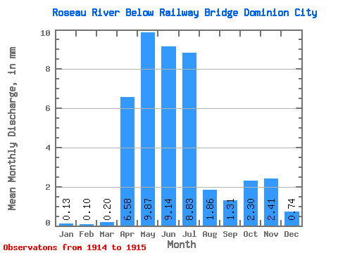
| Statistic | Jan | Feb | Mar | Apr | May | Jun | Jul | Aug | Sep | Oct | Nov | Dec | Annual |
|---|---|---|---|---|---|---|---|---|---|---|---|---|---|
| Mean | 0.14 | 0.10 | 0.20 | 6.58 | 9.87 | 9.14 | 8.83 | 1.86 | 1.31 | 2.30 | 2.41 | 0.74 | 42.75 |
| Standard Deviation | 2.67 | 0.64 | 0.03 | 5.95 | 0.94 | 1.38 | 2.25 | 1.75 | 0.19 | ||||
| Min | 0.14 | 0.10 | 0.20 | 4.70 | 9.42 | 9.12 | 4.62 | 1.20 | 0.34 | 0.71 | 1.17 | 0.60 | 42.75 |
| Max | 0.14 | 0.10 | 0.20 | 8.47 | 10.32 | 9.16 | 13.03 | 2.53 | 2.28 | 3.89 | 3.65 | 0.88 | 42.75 |
| Coefficient of Variation | 0.41 | 0.07 | 0.00 | 0.67 | 0.51 | 1.05 | 0.98 | 0.73 | 0.26 |
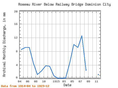
| Year | Jan | Feb | Mar | Apr | May | Jun | Jul | Aug | Sep | Oct | Nov | Dec | Annual | 1914 | 8.47 | 9.42 | 9.12 | 4.62 | 1.20 | 2.28 | 3.89 | 3.65 | 0.88 | 1915 | 0.14 | 0.10 | 0.20 | 4.70 | 10.32 | 9.16 | 13.03 | 2.53 | 0.34 | 0.71 | 1.17 | 0.60 | 42.75 |
|---|
 Return to R-Arctic Net Home Page