|
|
|||||||||||||||||
| Point ID: 2887 | Downloads | Plots | Site Data | Code: 05MF003 |
|
|
|||||||||||||||||
| Download | |
|---|---|
| Site Descriptor Information | Site Time Series Data |
| Link to all available data | |
|
|
| View: | Statistics | Time Series |
| Units: | m3/s |
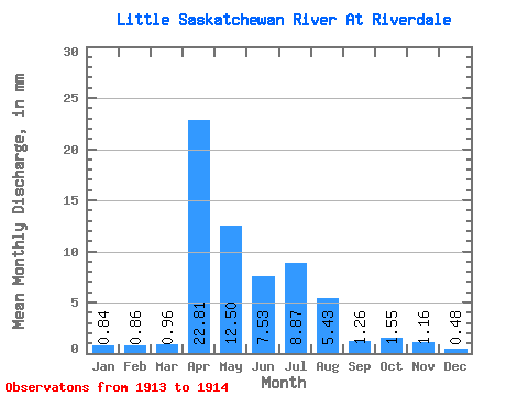
| Statistic | Jan | Feb | Mar | Apr | May | Jun | Jul | Aug | Sep | Oct | Nov | Dec | Annual |
|---|---|---|---|---|---|---|---|---|---|---|---|---|---|
| Mean | 0.84 | 0.87 | 0.96 | 22.81 | 12.50 | 7.53 | 8.87 | 5.43 | 1.26 | 1.55 | 1.16 | 0.48 | 66.72 |
| Standard Deviation | 0.51 | 0.62 | 0.68 | 1.62 | |||||||||
| Min | 0.48 | 0.44 | 0.48 | 21.67 | 12.50 | 7.53 | 8.87 | 5.43 | 1.26 | 1.55 | 1.16 | 0.48 | 66.72 |
| Max | 1.20 | 1.31 | 1.44 | 23.96 | 12.50 | 7.53 | 8.87 | 5.43 | 1.26 | 1.55 | 1.16 | 0.48 | 66.72 |
| Coefficient of Variation | 0.61 | 0.71 | 0.71 | 0.07 |
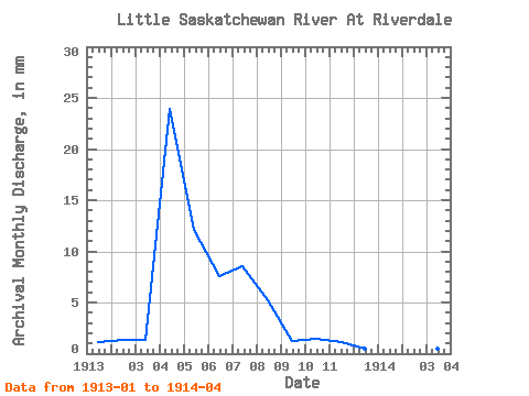
| Year | Jan | Feb | Mar | Apr | May | Jun | Jul | Aug | Sep | Oct | Nov | Dec | Annual | 1913 | 1.20 | 1.31 | 1.44 | 23.96 | 12.50 | 7.53 | 8.87 | 5.43 | 1.26 | 1.55 | 1.16 | 0.48 | 66.72 | 1914 | 0.48 | 0.44 | 0.48 | 21.67 |
|---|
 Return to R-Arctic Net Home Page