|
|
|||||||||||||||||
| Point ID: 2815 | Downloads | Plots | Site Data | Code: 05LJ001 |
|
|
|||||||||||||||||
| Download | |
|---|---|
| Site Descriptor Information | Site Time Series Data |
| Link to all available data | |
|
|
| View: | Statistics | Time Series |
| Units: | m3/s |
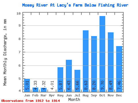
| Statistic | Jan | Feb | Mar | Apr | May | Jun | Jul | Aug | Sep | Oct | Nov | Dec | Annual |
|---|---|---|---|---|---|---|---|---|---|---|---|---|---|
| Mean | 5.00 | 4.37 | 4.32 | 4.01 | 5.87 | 6.43 | 5.66 | 8.62 | 8.20 | 9.70 | 8.49 | 7.46 | |
| Standard Deviation | 0.86 | 1.77 | 2.46 | 0.96 | 5.25 | 4.51 | 2.63 | ||||||
| Min | 5.00 | 4.37 | 4.32 | 4.01 | 5.87 | 5.82 | 4.41 | 6.88 | 7.53 | 5.99 | 5.30 | 5.60 | |
| Max | 5.00 | 4.37 | 4.32 | 4.01 | 5.87 | 7.04 | 6.91 | 10.37 | 8.88 | 13.40 | 11.68 | 9.32 | |
| Coefficient of Variation | 0.13 | 0.31 | 0.29 | 0.12 | 0.54 | 0.53 | 0.35 |
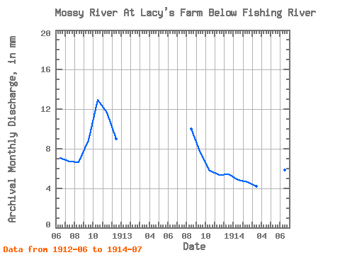
| Year | Jan | Feb | Mar | Apr | May | Jun | Jul | Aug | Sep | Oct | Nov | Dec | Annual | 1912 | 7.04 | 6.91 | 6.88 | 8.88 | 13.40 | 11.68 | 9.32 | 1913 | 10.37 | 7.53 | 5.99 | 5.30 | 5.60 | 1914 | 5.00 | 4.37 | 4.32 | 4.01 | 5.87 | 5.82 | 4.41 |
|---|
 Return to R-Arctic Net Home Page