|
|
|||||||||||||||||
| Point ID: 2755 | Downloads | Plots | Site Data | Other Close Sites | Code: 10AC006 |
|
|
|||||||||||||||||
| Download | |
|---|---|
| Site Descriptor Information | Site Time Series Data |
| Link to all available data | |
|
|
| View: | Statistics | Time Series |
| Units: | m3/s |
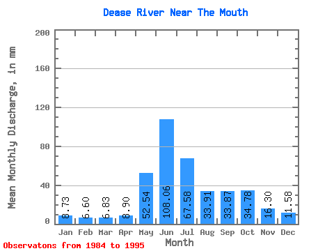
| Statistic | Jan | Feb | Mar | Apr | May | Jun | Jul | Aug | Sep | Oct | Nov | Dec | Annual |
|---|---|---|---|---|---|---|---|---|---|---|---|---|---|
| Mean | 8.73 | 6.65 | 6.83 | 8.90 | 52.53 | 108.06 | 67.57 | 33.91 | 33.88 | 34.78 | 16.30 | 11.58 | 388.81 |
| Standard Deviation | 1.89 | 1.27 | 1.45 | 2.84 | 17.01 | 29.51 | 20.79 | 6.04 | 13.62 | 17.71 | 6.60 | 3.66 | 51.98 |
| Min | 5.72 | 4.24 | 4.12 | 5.77 | 24.38 | 48.80 | 33.24 | 26.23 | 18.95 | 16.16 | 9.44 | 7.37 | 274.52 |
| Max | 12.54 | 8.94 | 9.25 | 16.91 | 82.56 | 160.70 | 107.49 | 49.13 | 59.53 | 80.16 | 33.25 | 20.13 | 440.93 |
| Coefficient of Variation | 0.22 | 0.19 | 0.21 | 0.32 | 0.32 | 0.27 | 0.31 | 0.18 | 0.40 | 0.51 | 0.41 | 0.32 | 0.13 |
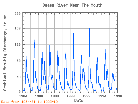
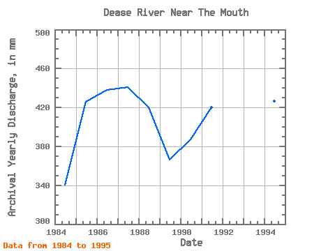
| Year | Jan | Feb | Mar | Apr | May | Jun | Jul | Aug | Sep | Oct | Nov | Dec | Annual | 1984 | 6.94 | 5.38 | 5.41 | 6.79 | 38.41 | 91.35 | 58.18 | 37.86 | 35.93 | 28.81 | 15.53 | 10.64 | 340.52 | 1985 | 7.94 | 5.99 | 6.50 | 7.44 | 32.88 | 131.75 | 107.49 | 37.86 | 37.90 | 30.10 | 12.67 | 8.46 | 426.08 | 1986 | 8.16 | 5.82 | 6.35 | 5.77 | 24.38 | 107.25 | 81.63 | 34.72 | 32.35 | 80.16 | 33.25 | 20.13 | 438.48 | 1987 | 12.54 | 8.94 | 9.25 | 9.26 | 52.82 | 118.52 | 84.03 | 33.43 | 37.90 | 45.62 | 17.75 | 11.97 | 440.93 | 1988 | 9.90 | 7.72 | 7.46 | 8.35 | 60.95 | 104.57 | 87.91 | 49.13 | 31.28 | 26.78 | 15.30 | 12.52 | 420.26 | 1989 | 8.81 | 7.18 | 7.09 | 10.17 | 82.56 | 99.03 | 49.13 | 31.95 | 19.84 | 23.46 | 16.12 | 12.34 | 366.51 | 1990 | 8.70 | 6.98 | 8.77 | 9.47 | 64.27 | 147.83 | 59.84 | 26.23 | 19.66 | 16.16 | 10.28 | 9.64 | 387.66 | 1991 | 8.24 | 6.83 | 6.37 | 9.03 | 60.39 | 92.95 | 54.11 | 32.88 | 59.53 | 50.79 | 23.77 | 16.20 | 420.24 | 1992 | 11.47 | 7.52 | 7.33 | 7.74 | 37.12 | 160.70 | 68.52 | 29.00 | 24.49 | 24.01 | 10.42 | 7.37 | 395.95 | 1993 | 7.20 | 5.69 | 5.50 | 9.12 | 70.37 | 87.06 | 49.31 | 26.96 | 18.95 | 25.86 | 15.19 | 7.37 | 327.48 | 1994 | 5.72 | 4.24 | 4.12 | 6.76 | 59.28 | 106.90 | 77.39 | 34.17 | 58.63 | 43.22 | 15.86 | 11.88 | 427.02 | 1995 | 9.16 | 7.52 | 7.83 | 16.91 | 46.91 | 48.80 | 33.24 | 32.69 | 30.03 | 22.35 | 9.44 | 10.42 | 274.52 |
|---|
| Other Close Sites | ||||||
|---|---|---|---|---|---|---|
| PointID | Latitude | Longitude | Drainage Area | Source | Name | |
| 5839 | "LIARD RIVER AT UPPER CROSSING" | 60.05 | 2067643 | Hydat | ||
 Return to R-Arctic Net Home Page