|
|
|||||||||||||||||
| Point ID: 2745 | Downloads | Plots | Site Data | Code: 09AA010 |
|
|
|||||||||||||||||
| Download | |
|---|---|
| Site Descriptor Information | Site Time Series Data |
| Link to all available data | |

|

|
| View: | Statistics | Time Series |
| Units: | m3/s |
| Statistic | Jan | Feb | Mar | Apr | May | Jun | Jul | Aug | Sep | Oct | Nov | Dec | Annual |
|---|---|---|---|---|---|---|---|---|---|---|---|---|---|
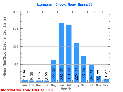
| Mean | 13.84 | 9.47 | 9.16 | 8.99 | 122.31 | 332.39 | 319.19 | 220.74 | 145.20 | 94.78 | 33.77 | 19.28 | 1309.60 |
| Standard Deviation | 4.46 | 3.17 | 6.41 | 6.46 | 64.55 | 63.45 | 67.42 | 35.02 | 58.11 | 37.77 | 16.35 | 6.21 | 144.36 |
| Min | 6.45 | 1.54 | 2.34 | 4.60 | 23.99 | 205.20 | 208.66 | 157.33 | 55.62 | 42.62 | 11.88 | 7.09 | 1069.14 |
| Max | 28.01 | 15.15 | 39.39 | 35.75 | 309.09 | 503.28 | 458.61 | 332.52 | 334.80 | 184.11 | 79.16 | 35.04 | 1599.61 |
| Coefficient of Variation | 0.32 | 0.34 | 0.70 | 0.72 | 0.53 | 0.19 | 0.21 | 0.16 | 0.40 | 0.40 | 0.48 | 0.32 | 0.11 |
| Year | Jan | Feb | Mar | Apr | May | Jun | Jul | Aug | Sep | Oct | Nov | Dec | Annual | 1954 | 53.67 | 36.50 | 18.08 | 1955 | 12.39 | 9.09 | 8.60 | 8.11 | 25.00 | 205.20 | 458.61 | 237.67 | 171.72 | 1956 | 6.47 | 5.46 | 108.57 | 252.72 | 333.63 | 248.83 | 200.88 | 131.67 | 11.88 | 29.12 | 1957 | 10.01 | 1.54 | 2.34 | 5.00 | 155.10 | 414.72 | 280.07 | 230.98 | 247.32 | 120.51 | 52.06 | 14.84 | 1530.56 | 1958 | 11.49 | 6.13 | 5.47 | 5.90 | 148.41 | 331.56 | 265.57 | 180.76 | 55.62 | 54.56 | 22.68 | 11.04 | 1093.62 | 1959 | 10.21 | 6.75 | 5.30 | 4.68 | 80.34 | 408.24 | 275.61 | 217.59 | 69.12 | 57.24 | 17.06 | 19.08 | 1167.14 | 1960 | 12.83 | 8.16 | 6.21 | 35.75 | 204.20 | 305.64 | 291.23 | 222.05 | 169.56 | 76.66 | 33.48 | 19.97 | 1379.43 | 1961 | 15.29 | 10.37 | 11.38 | 8.45 | 155.10 | 370.44 | 439.64 | 332.52 | 137.16 | 94.40 | 21.28 | 13.95 | 1599.61 | 1962 | 13.72 | 9.29 | 6.88 | 5.75 | 73.53 | 317.52 | 329.17 | 213.12 | 191.16 | 79.45 | 55.84 | 25.11 | 1316.35 | 1963 | 13.28 | 6.31 | 5.71 | 4.60 | 145.06 | 238.68 | 336.98 | 224.28 | 199.80 | 127.20 | 28.62 | 17.85 | 1340.19 | 1964 | 15.40 | 13.12 | 10.30 | 8.89 | 23.99 | 503.28 | 332.52 | 214.24 | 87.16 | 28.84 | 25.55 | 1965 | 28.01 | 13.12 | 6.84 | 4.89 | 75.77 | 272.16 | 390.54 | 246.60 | 116.64 | 52.44 | 26.24 | 15.96 | 1241.76 | 1966 | 12.16 | 6.17 | 6.20 | 4.74 | 59.14 | 351.00 | 334.75 | 193.04 | 164.16 | 120.51 | 27.22 | 18.63 | 1292.89 | 1967 | 12.61 | 9.41 | 9.14 | 7.97 | 111.58 | 390.96 | 208.66 | 222.05 | 334.80 | 57.02 | 25.27 | 15.29 | 1405.22 | 1968 | 8.89 | 13.52 | 28.45 | 10.68 | 184.11 | 255.96 | 274.50 | 176.30 | 155.52 | 62.93 | 17.71 | 13.05 | 1195.73 | 1969 | 8.25 | 5.33 | 6.03 | 6.90 | 133.90 | 416.88 | 218.70 | 157.33 | 105.08 | 81.01 | 65.66 | 19.42 | 1222.42 | 1970 | 11.11 | 8.85 | 9.41 | 8.52 | 84.36 | 320.76 | 272.26 | 219.82 | 112.32 | 117.16 | 46.55 | 16.40 | 1222.27 | 1971 | 12.72 | 8.00 | 6.82 | 6.05 | 31.91 | 353.16 | 381.62 | 253.29 | 114.48 | 50.10 | 18.14 | 12.94 | 1243.64 | 1972 | 8.25 | 6.79 | 5.95 | 5.29 | 78.67 | 408.24 | 282.31 | 270.03 | 127.44 | 66.17 | 19.87 | 9.50 | 1284.33 | 1973 | 9.83 | 7.24 | 6.83 | 6.25 | 129.44 | 260.28 | 310.20 | 208.66 | 81.97 | 42.62 | 13.18 | 7.09 | 1076.64 | 1974 | 6.45 | 5.26 | 4.92 | 5.17 | 95.07 | 244.08 | 257.76 | 210.89 | 172.80 | 109.46 | 79.16 | 25.00 | 1211.06 | 1975 | 18.19 | 9.91 | 8.95 | 6.84 | 74.20 | 299.16 | 453.03 | 196.39 | 217.08 | 98.08 | 22.03 | 15.18 | 1412.31 | 1976 | 12.16 | 10.57 | 7.84 | 6.48 | 63.16 | 329.40 | 312.43 | 225.40 | 113.40 | 74.09 | 77.00 | 27.23 | 1254.76 | 1977 | 15.73 | 15.15 | 11.12 | 17.50 | 119.39 | 365.04 | 345.91 | 275.61 | 119.88 | 69.74 | 25.92 | 13.39 | 1388.06 | 1978 | 10.36 | 7.76 | 7.66 | 8.64 | 104.55 | 336.96 | 239.90 | 176.30 | 85.00 | 145.06 | 36.61 | 19.53 | 1173.17 | 1979 | 12.83 | 6.90 | 7.66 | 8.35 | 137.25 | 245.16 | 370.46 | 234.32 | 166.32 | 158.45 | 28.51 | 21.31 | 1387.74 | 1980 | 13.50 | 11.29 | 8.88 | 7.11 | 152.87 | 380.16 | 305.74 | 222.05 | 100.76 | 145.06 | 47.30 | 21.98 | 1409.83 | 1981 | 18.86 | 14.95 | 12.61 | 9.10 | 225.40 | 316.44 | 334.75 | 273.38 | 205.20 | 97.64 | 47.95 | 23.54 | 1571.79 | 1982 | 10.68 | 6.65 | 7.15 | 6.57 | 48.43 | 335.88 | 259.99 | 162.91 | 116.64 | 127.20 | 26.89 | 19.08 | 1124.33 | 1983 | 14.84 | 7.23 | 5.56 | 7.00 | 156.22 | 348.84 | 225.40 | 187.46 | 117.72 | 71.86 | 23.98 | 11.16 | 1173.06 | 1984 | 17.96 | 11.18 | 7.83 | 7.80 | 132.78 | 274.32 | 216.47 | 222.05 | 87.05 | 64.94 | 17.71 | 14.62 | 1069.14 | 1985 | 14.28 | 9.07 | 11.94 | 5.94 | 71.41 | 274.32 | 428.48 | 197.50 | 109.08 | 56.68 | 21.38 | 16.40 | 1208.94 | 1986 | 13.61 | 9.77 | 8.62 | 7.46 | 76.44 | 359.64 | 415.09 | 230.98 | 85.54 | 145.06 | 38.77 | 20.09 | 1402.72 | 1987 | 15.73 | 9.75 | 7.06 | 6.16 | 107.79 | 266.76 | 354.83 | 181.88 | 194.40 | 158.45 | 39.53 | 25.33 | 1360.61 | 1988 | 13.72 | 12.10 | 384.48 | 339.21 | 218.70 | 132.84 | 184.11 | 32.94 | 32.36 | 1989 | 14.95 | 12.71 | 9.15 | 30.13 | 309.09 | 325.08 | 297.93 | 207.54 | 139.32 | 88.60 | 50.98 | 35.04 | 1512.25 | 1990 | 27.00 | 12.51 | 9.52 | 12.42 | 193.04 | 366.12 | 295.70 | 271.15 | 253.80 | 70.74 | 1991 | 7.77 | 8.16 | 170.72 | 331.56 | 262.22 | 223.17 | 185.76 | 146.17 | 29.81 | 23.54 | 1992 | 19.19 | 13.72 | 39.39 | 17.71 | 117.16 | 407.16 | 425.13 | 242.14 | 97.31 | 63.38 | 30.67 | 20.31 | 1485.84 | 1993 | 15.62 | 14.64 | 10.31 | 9.27 | 284.54 | 395.28 | 291.23 | 179.65 | 120.96 | 81.57 | 38.12 | 24.55 | 1459.23 |
|---|
 Return to R-Arctic Net Home Page