|
|
|||||||||||||||||
| Point ID: 271 | Downloads | Plots | Site Data | Code: 05BF022 |
|
|
|||||||||||||||||
| Download | |
|---|---|
| Site Descriptor Information | Site Time Series Data |
| Link to all available data | |
|
|
| View: | Statistics | Time Series |
| Units: | m3/s |
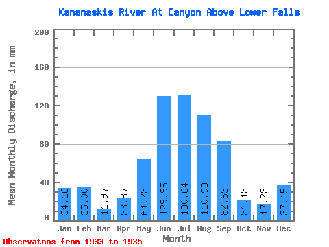
| Statistic | Jan | Feb | Mar | Apr | May | Jun | Jul | Aug | Sep | Oct | Nov | Dec | Annual |
|---|---|---|---|---|---|---|---|---|---|---|---|---|---|
| Mean | 34.15 | 35.30 | 11.97 | 23.87 | 64.21 | 129.95 | 130.62 | 110.91 | 82.63 | 21.42 | 17.23 | 37.14 | |
| Standard Deviation | 57.79 | 14.98 | 3.97 | 2.70 | |||||||||
| Min | 34.15 | 35.30 | 11.97 | 23.87 | 23.35 | 119.36 | 130.62 | 110.91 | 82.63 | 18.61 | 15.33 | 37.14 | |
| Max | 34.15 | 35.30 | 11.97 | 23.87 | 105.08 | 140.55 | 130.62 | 110.91 | 82.63 | 24.23 | 19.14 | 37.14 | |
| Coefficient of Variation | 0.90 | 0.12 | 0.19 | 0.16 |
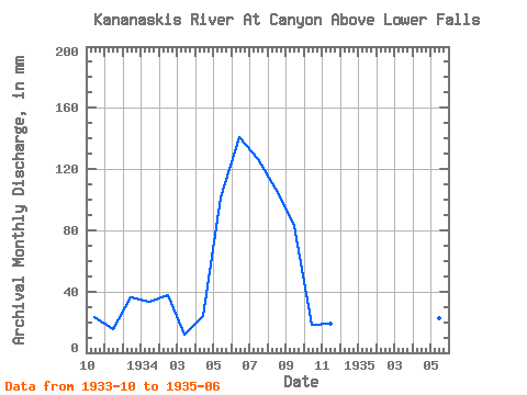
| Year | Jan | Feb | Mar | Apr | May | Jun | Jul | Aug | Sep | Oct | Nov | Dec | Annual | 1933 | 24.23 | 15.33 | 37.14 | 1934 | 34.15 | 35.30 | 11.97 | 23.87 | 105.08 | 140.55 | 130.62 | 110.91 | 82.63 | 18.61 | 19.14 | 1935 | 23.35 | 119.36 |
|---|
 Return to R-Arctic Net Home Page