|
|
|||||||||||||||||
| Point ID: 248 | Downloads | Plots | Site Data | Code: 05BE001 |
|
|
|||||||||||||||||
| Download | |
|---|---|
| Site Descriptor Information | Site Time Series Data |
| Link to all available data | |
|
|
| View: | Statistics | Time Series |
| Units: | m3/s |
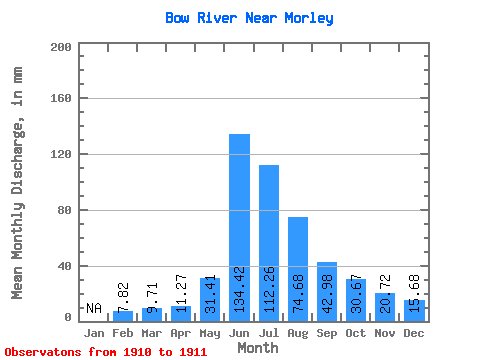
| Statistic | Jan | Feb | Mar | Apr | May | Jun | Jul | Aug | Sep | Oct | Nov | Dec | Annual |
|---|---|---|---|---|---|---|---|---|---|---|---|---|---|
| Mean | 7.89 | 9.71 | 11.27 | 31.41 | 134.42 | 112.25 | 74.67 | 42.98 | 30.66 | 20.72 | 15.68 | ||
| Standard Deviation | 6.13 | 1.76 | 9.15 | 6.81 | 6.69 | ||||||||
| Min | 7.89 | 9.71 | 11.27 | 31.41 | 130.08 | 111.00 | 68.19 | 38.16 | 25.93 | 20.72 | 15.68 | ||
| Max | 7.89 | 9.71 | 11.27 | 31.41 | 138.75 | 113.49 | 81.14 | 47.79 | 35.39 | 20.72 | 15.68 | ||
| Coefficient of Variation | 0.05 | 0.02 | 0.12 | 0.16 | 0.22 |
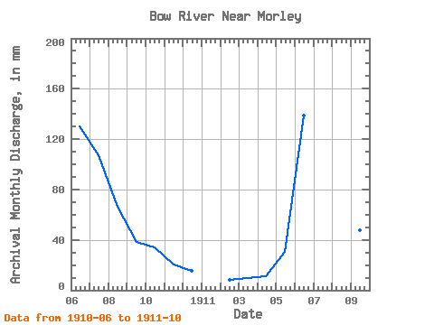
| Year | Jan | Feb | Mar | Apr | May | Jun | Jul | Aug | Sep | Oct | Nov | Dec | Annual | 1910 | 130.08 | 111.00 | 68.19 | 38.16 | 35.39 | 20.72 | 15.68 | 1911 | 7.89 | 9.71 | 11.27 | 31.41 | 138.75 | 113.49 | 81.14 | 47.79 | 25.93 |
|---|
 Return to R-Arctic Net Home Page