|
|
|||||||||||||||||
| Point ID: 241 | Downloads | Plots | Site Data | Code: 05BC005 |
|
|
|||||||||||||||||
| Download | |
|---|---|
| Site Descriptor Information | Site Time Series Data |
| Link to all available data | |
|
|
| View: | Statistics | Time Series |
| Units: | m3/s |
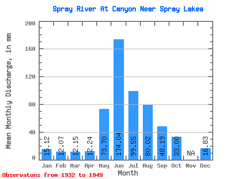
| Statistic | Jan | Feb | Mar | Apr | May | Jun | Jul | Aug | Sep | Oct | Nov | Dec | Annual |
|---|---|---|---|---|---|---|---|---|---|---|---|---|---|
| Mean | 15.12 | 12.18 | 12.15 | 12.24 | 73.69 | 174.04 | 99.53 | 80.01 | 48.19 | 32.99 | 16.83 | ||
| Standard Deviation | 21.77 | 88.07 | 27.22 | 24.50 | 1.24 | ||||||||
| Min | 15.12 | 12.18 | 12.15 | 12.24 | 58.29 | 111.77 | 80.28 | 62.69 | 47.32 | 32.99 | 16.83 | ||
| Max | 15.12 | 12.18 | 12.15 | 12.24 | 89.08 | 236.31 | 118.78 | 97.33 | 49.07 | 32.99 | 16.83 | ||
| Coefficient of Variation | 0.30 | 0.51 | 0.27 | 0.31 | 0.03 |
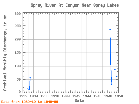
| Year | Jan | Feb | Mar | Apr | May | Jun | Jul | Aug | Sep | Oct | Nov | Dec | Annual | 1932 | 16.83 | 1933 | 15.12 | 12.18 | 12.15 | 12.24 | 58.29 | 1948 | 236.31 | 118.78 | 97.33 | 47.32 | 32.99 | 1949 | 89.08 | 111.77 | 80.28 | 62.69 | 49.07 |
|---|
 Return to R-Arctic Net Home Page