|
|
|||||||||||||||||
| Point ID: 239 | Downloads | Plots | Site Data | Code: 05BC002 |
|
|
|||||||||||||||||
| Download | |
|---|---|
| Site Descriptor Information | Site Time Series Data |
| Link to all available data | |
|
|
| View: | Statistics | Time Series |
| Units: | m3/s |
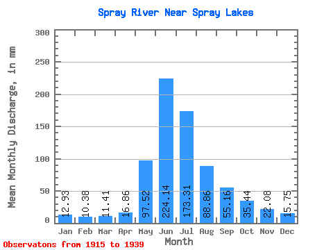
| Statistic | Jan | Feb | Mar | Apr | May | Jun | Jul | Aug | Sep | Oct | Nov | Dec | Annual |
|---|---|---|---|---|---|---|---|---|---|---|---|---|---|
| Mean | 12.93 | 10.47 | 11.41 | 16.86 | 97.50 | 224.14 | 173.29 | 88.84 | 55.16 | 35.43 | 22.08 | 15.75 | 749.04 |
| Standard Deviation | 3.68 | 2.94 | 2.90 | 9.72 | 45.64 | 53.03 | 73.28 | 22.41 | 16.94 | 9.82 | 6.59 | 2.99 | 127.00 |
| Min | 9.00 | 7.52 | 8.11 | 7.63 | 39.72 | 101.52 | 96.71 | 57.13 | 30.60 | 22.76 | 14.83 | 12.35 | 574.14 |
| Max | 24.32 | 19.79 | 18.82 | 42.91 | 202.34 | 318.24 | 429.22 | 153.99 | 98.64 | 57.50 | 36.07 | 21.80 | 925.32 |
| Coefficient of Variation | 0.28 | 0.28 | 0.25 | 0.58 | 0.47 | 0.24 | 0.42 | 0.25 | 0.31 | 0.28 | 0.30 | 0.19 | 0.17 |
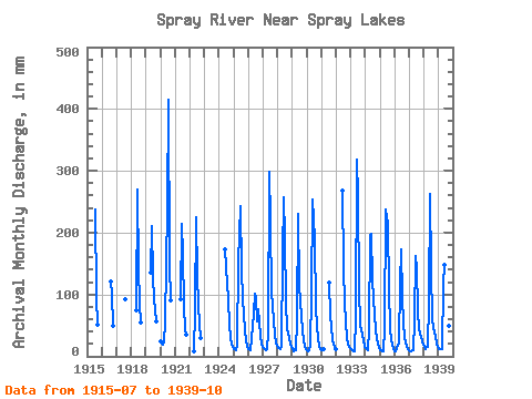
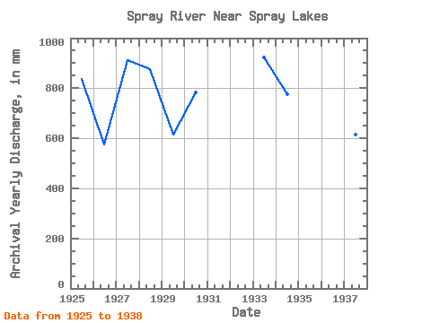
| Year | Jan | Feb | Mar | Apr | May | Jun | Jul | Aug | Sep | Oct | Nov | Dec | Annual | 1915 | 244.74 | 98.19 | 51.70 | 1916 | 124.97 | 98.64 | 51.10 | 1917 | 94.47 | 1918 | 77.36 | 270.00 | 146.55 | 87.03 | 54.72 | 1919 | 139.85 | 210.24 | 131.67 | 94.47 | 57.10 | 1920 | 24.32 | 19.79 | 18.82 | 22.61 | 58.77 | 239.04 | 429.22 | 153.99 | 90.00 | 1921 | 94.47 | 214.56 | 168.86 | 86.29 | 42.77 | 35.41 | 1922 | 8.93 | 76.62 | 224.64 | 134.64 | 87.03 | 51.70 | 31.47 | 1924 | 172.80 | 148.78 | 94.47 | 49.75 | 32.58 | 19.37 | 16.59 | 1925 | 12.12 | 10.30 | 9.52 | 18.50 | 157.70 | 242.64 | 145.80 | 94.47 | 66.53 | 42.70 | 23.54 | 17.48 | 838.68 | 1926 | 11.98 | 10.51 | 10.34 | 30.46 | 70.82 | 101.52 | 96.71 | 57.80 | 75.60 | 57.50 | 32.76 | 19.64 | 574.14 | 1927 | 15.03 | 10.78 | 9.30 | 11.59 | 39.72 | 298.08 | 226.14 | 102.66 | 84.96 | 56.39 | 36.07 | 21.80 | 911.22 | 1928 | 13.91 | 12.81 | 12.79 | 14.90 | 168.12 | 257.76 | 200.85 | 87.78 | 45.36 | 30.35 | 18.72 | 15.62 | 875.42 | 1929 | 11.53 | 7.52 | 12.05 | 9.36 | 60.70 | 231.12 | 118.28 | 68.07 | 40.54 | 27.60 | 15.19 | 12.87 | 614.18 | 1930 | 11.08 | 8.27 | 9.30 | 19.30 | 103.40 | 253.44 | 194.90 | 83.32 | 47.09 | 30.28 | 14.83 | 12.50 | 785.27 | 1931 | 10.64 | 9.69 | 11.38 | 123.49 | 67.25 | 48.02 | 27.60 | 19.30 | 17.41 | 1932 | 11.90 | 267.84 | 147.29 | 89.27 | 55.37 | 29.68 | 18.43 | 13.32 | 1933 | 11.46 | 8.81 | 8.11 | 8.57 | 63.16 | 318.24 | 266.31 | 113.81 | 51.77 | 35.41 | 25.70 | 16.59 | 925.32 | 1934 | 13.24 | 10.91 | 9.37 | 42.91 | 202.34 | 197.28 | 126.46 | 70.22 | 41.69 | 30.43 | 21.46 | 13.39 | 776.65 | 1935 | 11.08 | 9.29 | 8.78 | 7.63 | 47.01 | 237.60 | 221.68 | 110.84 | 46.30 | 26.71 | 18.58 | 12.35 | 755.25 | 1936 | 9.00 | 8.27 | 13.98 | 22.10 | 122.00 | 173.52 | 98.94 | 57.13 | 30.60 | 22.76 | 15.62 | 12.42 | 584.52 | 1937 | 9.82 | 8.40 | 9.82 | 9.14 | 60.92 | 162.72 | 148.03 | 76.62 | 43.34 | 38.38 | 31.32 | 19.34 | 615.64 | 1938 | 17.70 | 11.45 | 15.25 | 14.54 | 91.50 | 262.08 | 145.06 | 61.52 | 45.65 | 33.03 | 20.30 | 14.95 | 732.16 | 1939 | 11.98 | 10.30 | 12.27 | 12.38 | 120.51 | 147.60 | 148.03 | 70.59 | 49.54 | 33.85 |
|---|
 Return to R-Arctic Net Home Page