|
|
|||||||||||||||||
| Point ID: 227 | Downloads | Plots | Site Data | Code: 05BA005 |
|
|
|||||||||||||||||
| Download | |
|---|---|
| Site Descriptor Information | Site Time Series Data |
| Link to all available data | |
|
|
| View: | Statistics | Time Series |
| Units: | m3/s |
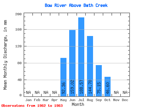
| Statistic | Jan | Feb | Mar | Apr | May | Jun | Jul | Aug | Sep | Oct | Nov | Dec | Annual |
|---|---|---|---|---|---|---|---|---|---|---|---|---|---|
| Mean | 92.34 | 159.02 | 188.54 | 144.67 | 75.15 | 46.60 | |||||||
| Standard Deviation | 51.09 | 6.53 | 1.09 | 41.19 | 18.66 | ||||||||
| Min | 92.34 | 122.90 | 183.92 | 143.90 | 46.03 | 33.40 | |||||||
| Max | 92.34 | 195.15 | 193.16 | 145.44 | 104.28 | 59.79 | |||||||
| Coefficient of Variation | 0.32 | 0.04 | 0.01 | 0.55 | 0.40 |
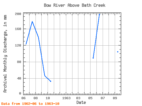
| Year | Jan | Feb | Mar | Apr | May | Jun | Jul | Aug | Sep | Oct | Nov | Dec | Annual | 1962 | 122.90 | 183.92 | 143.90 | 46.03 | 33.40 | 1963 | 92.34 | 195.15 | 193.16 | 145.44 | 104.28 | 59.79 |
|---|
 Return to R-Arctic Net Home Page