|
|
|||||||||||||||||
| Point ID: 20 | Downloads | Plots | Site Data | Code: 05AA025 |
|
|
|||||||||||||||||
| Download | |
|---|---|
| Site Descriptor Information | Site Time Series Data |
| Link to all available data | |
|
|
| View: | Statistics | Time Series |
| Units: | m3/s |
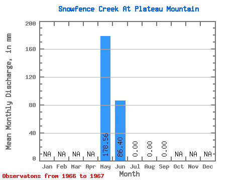
| Statistic | Jan | Feb | Mar | Apr | May | Jun | Jul | Aug | Sep | Oct | Nov | Dec | Annual |
|---|---|---|---|---|---|---|---|---|---|---|---|---|---|
| Mean | 133.90 | 43.20 | 0.00 | 0.00 | 0.00 | ||||||||
| Standard Deviation | 63.12 | 61.09 | 0.00 | ||||||||||
| Min | 89.27 | 0.00 | 0.00 | 0.00 | 0.00 | ||||||||
| Max | 178.53 | 86.40 | 0.00 | 0.00 | 0.00 | ||||||||
| Coefficient of Variation | 0.47 | 1.41 |
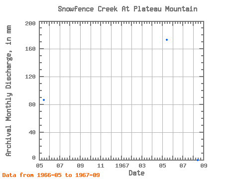
| Year | Jan | Feb | Mar | Apr | May | Jun | Jul | Aug | Sep | Oct | Nov | Dec | Annual | 1966 | 89.27 | 0.00 | 0.00 | 1967 | 178.53 | 86.40 | 0.00 | 0.00 | 0.00 |
|---|
 Return to R-Arctic Net Home Page