|
|
|||||||||||||||||
| Point ID: 151 | Downloads | Plots | Site Data | Code: 05AE040 |
|
|
|||||||||||||||||
| Download | |
|---|---|
| Site Descriptor Information | Site Time Series Data |
| Link to all available data | |

|

|
| View: | Statistics | Time Series |
| Units: | m3/s |
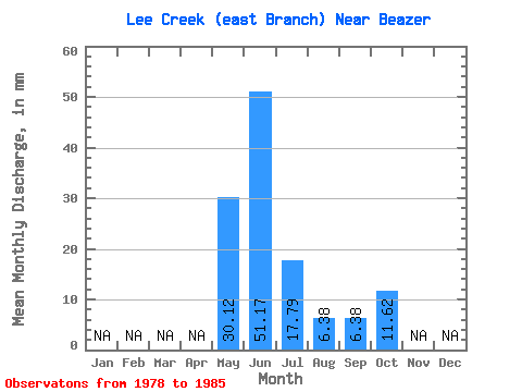
| Statistic | Jan | Feb | Mar | Apr | May | Jun | Jul | Aug | Sep | Oct | Nov | Dec | Annual |
|---|---|---|---|---|---|---|---|---|---|---|---|---|---|
| Mean | 30.12 | 51.19 | 17.75 | 6.39 | 6.41 | 11.59 | |||||||
| Standard Deviation | 29.30 | 9.23 | 4.73 | 6.58 | 16.25 | ||||||||
| Min | 30.12 | 16.32 | 6.09 | 1.56 | 1.37 | 2.13 | |||||||
| Max | 30.12 | 97.40 | 33.31 | 16.94 | 18.59 | 43.94 | |||||||
| Coefficient of Variation | 0.57 | 0.52 | 0.74 | 1.03 | 1.40 |
| Year | Jan | Feb | Mar | Apr | May | Jun | Jul | Aug | Sep | Oct | Nov | Dec | Annual | 1978 | 33.31 | 16.94 | 13.38 | 1979 | 56.79 | 17.64 | 5.17 | 2.06 | 3.47 | 1980 | 97.40 | 20.20 | 7.87 | 9.26 | 12.12 | 1981 | 75.45 | 24.24 | 6.80 | 2.33 | 4.68 | 1982 | 57.62 | 21.47 | 3.33 | 2.47 | 3.19 | 1983 | 30.12 | 26.27 | 12.83 | 3.47 | 1.78 | 1984 | 16.32 | 6.09 | 1.56 | 1.37 | 2.13 | 1985 | 28.46 | 6.24 | 5.95 | 18.59 | 43.94 |
|---|
 Return to R-Arctic Net Home Page