|
|
|||||||||||||||||
| Point ID: 107 | Downloads | Plots | Site Data | Code: 05AD031 |
|
|
|||||||||||||||||
| Download | |
|---|---|
| Site Descriptor Information | Site Time Series Data |
| Link to all available data | |
|
|
| View: | Statistics | Time Series |
| Units: | m3/s |
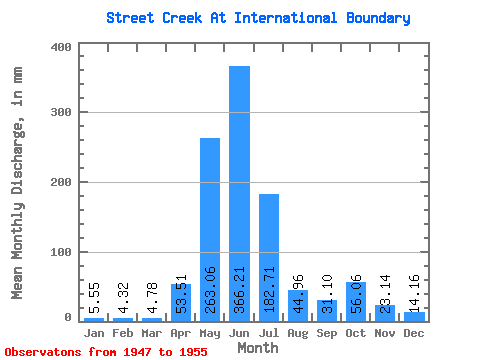
| Statistic | Jan | Feb | Mar | Apr | May | Jun | Jul | Aug | Sep | Oct | Nov | Dec | Annual |
|---|---|---|---|---|---|---|---|---|---|---|---|---|---|
| Mean | 5.55 | 4.39 | 4.71 | 53.47 | 262.99 | 366.19 | 182.70 | 44.98 | 31.08 | 56.07 | 23.17 | 14.08 | 1070.88 |
| Standard Deviation | 2.38 | 3.31 | 3.03 | 35.72 | 64.65 | 146.40 | 88.80 | 16.98 | 34.36 | 49.19 | 17.16 | 9.40 | 266.93 |
| Min | 2.68 | 2.44 | 2.10 | 16.85 | 133.71 | 183.85 | 51.27 | 14.15 | 7.04 | 4.21 | 2.41 | 2.68 | 759.13 |
| Max | 8.03 | 10.28 | 8.80 | 98.31 | 319.45 | 609.12 | 302.23 | 67.33 | 110.72 | 143.46 | 44.62 | 22.57 | 1297.90 |
| Coefficient of Variation | 0.43 | 0.75 | 0.64 | 0.67 | 0.25 | 0.40 | 0.49 | 0.38 | 1.11 | 0.88 | 0.74 | 0.67 | 0.25 |
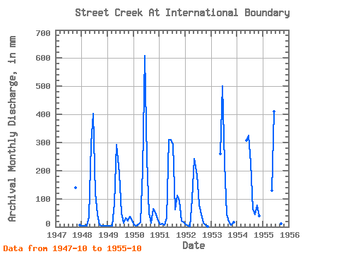
| Year | Jan | Feb | Mar | Apr | May | Jun | Jul | Aug | Sep | Oct | Nov | Dec | Annual | 1947 | 143.46 | 5.36 | 1948 | 3.83 | 2.96 | 2.68 | 37.40 | 304.14 | 401.76 | 124.34 | 46.29 | 7.04 | 4.21 | 2.59 | 2.68 | 937.97 | 1949 | 2.68 | 2.44 | 2.87 | 84.42 | 302.23 | 188.85 | 51.27 | 14.15 | 31.84 | 21.23 | 36.84 | 22.57 | 759.13 | 1950 | 5.36 | 2.96 | 8.80 | 16.85 | 208.50 | 609.12 | 250.58 | 50.50 | 12.78 | 66.76 | 44.62 | 21.81 | 1297.90 | 1951 | 8.03 | 10.28 | 7.08 | 30.36 | 319.45 | 311.04 | 302.23 | 62.36 | 110.72 | 94.69 | 21.11 | 17.98 | 1288.51 | 1952 | 7.84 | 3.31 | 2.10 | 98.31 | 250.58 | 183.85 | 81.30 | 44.76 | 13.52 | 5.93 | 2.41 | 1953 | 267.80 | 501.74 | 233.37 | 44.76 | 19.25 | 6.50 | 16.66 | 1954 | 317.53 | 324.00 | 235.28 | 67.33 | 42.95 | 79.38 | 37.95 | 1955 | 133.71 | 409.17 | 183.25 | 29.65 | 10.55 | 82.44 |
|---|
 Return to R-Arctic Net Home Page