|
|
|||||||||||||||||
| Point ID: 9619 | Downloads | Plots | Site Data | Code: 05093000 |
|
|
|||||||||||||||||
| Download | |
|---|---|
| Site Descriptor Information | Site Time Series Data |
| Link to all available data | |
|
|
| View: | Statistics | Time Series |
| Units: | mm |
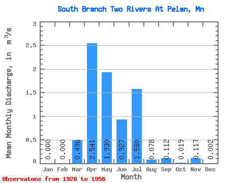
| Statistic | Jan | Feb | Mar | Apr | May | Jun | Jul | Aug | Sep | Oct | Nov | Dec | Annual |
|---|---|---|---|---|---|---|---|---|---|---|---|---|---|
| Mean | 0.00 | 0.00 | 0.50 | 2.54 | 1.93 | 0.93 | 1.58 | 0.08 | 0.11 | 0.02 | 0.12 | 0.00 | 0.44 |
| Standard Deviation | 0.00 | 0.00 | 1.50 | 2.75 | 2.29 | 1.93 | 5.47 | 0.17 | 0.33 | 0.04 | 0.41 | 0.01 | 0.31 |
| Min | 0.00 | 0.00 | 0.00 | 0.21 | 0.01 | 0.00 | 0.00 | 0.00 | 0.00 | 0.00 | 0.00 | 0.00 | 0.02 |
| Max | 0.00 | 0.00 | 5.46 | 9.77 | 7.87 | 6.89 | 19.79 | 0.52 | 1.23 | 0.15 | 1.55 | 0.03 | 0.85 |
| Coefficient of Variation | 3.03 | 1.08 | 1.18 | 2.08 | 3.46 | 2.25 | 2.97 | 2.34 | 3.55 | 3.12 | 0.71 |
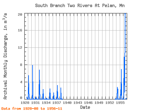
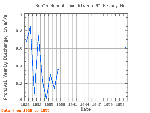
| Year | Jan | Feb | Mar | Apr | May | Jun | Jul | Aug | Sep | Oct | Nov | Dec | Annual | 1928 | 0.46 | 0.33 | 0.15 | 0.06 | 0.03 | 1929 | 0.00 | 0.00 | 5.46 | 1.83 | 0.56 | 0.26 | 0.03 | 0.00 | 0.00 | 0.00 | 0.00 | 0.00 | 0.68 | 1930 | 0.00 | 0.00 | 0.00 | 1.92 | 7.87 | 0.26 | 0.16 | 0.00 | 0.00 | 0.00 | 0.00 | 0.00 | 0.85 | 1931 | 0.00 | 0.00 | 0.13 | 0.52 | 0.19 | 0.08 | 0.02 | 0.01 | 0.00 | 0.00 | 0.00 | 0.00 | 0.08 | 1932 | 0.00 | 0.00 | 0.02 | 6.77 | 2.05 | 0.03 | 0.01 | 0.05 | 0.00 | 0.00 | 0.00 | 0.00 | 0.74 | 1933 | 0.00 | 0.00 | 0.11 | 2.27 | 0.24 | 0.11 | 0.00 | 0.00 | 0.00 | 0.00 | 0.00 | 0.00 | 0.23 | 1934 | 0.00 | 0.00 | 0.00 | 0.25 | 0.01 | 0.00 | 0.00 | 0.00 | 0.00 | 0.00 | 0.00 | 0.00 | 0.02 | 1935 | 0.00 | 0.00 | 0.61 | 2.41 | 0.49 | 0.07 | 0.01 | 0.00 | 0.00 | 0.00 | 0.00 | 0.00 | 0.30 | 1936 | 0.00 | 0.00 | 0.00 | 1.48 | 0.19 | 0.01 | 0.00 | 0.00 | 0.00 | 0.00 | 0.00 | 0.00 | 0.14 | 1937 | 0.00 | 0.00 | 0.00 | 0.68 | 3.17 | 0.20 | 0.24 | 0.03 | 0.00 | 0.00 | 0.00 | 0.00 | 0.36 | 1938 | 0.00 | 0.00 | 0.11 | 0.21 | 2.61 | 0.19 | 0.00 | 0.00 | 0.00 | 1953 | 0.02 | 0.01 | 0.00 | 1954 | 0.00 | 0.00 | 0.00 | 2.77 | 2.08 | 2.35 | 0.12 | 0.03 | 0.01 | 0.00 | 0.00 | 0.00 | 0.61 | 1955 | 0.00 | 0.00 | 0.00 | 2.18 | 0.91 | 6.89 | 0.16 | 0.00 | 0.00 | 0.00 | 0.00 | 0.00 | 0.85 | 1956 | 0.00 | 0.00 | 0.00 | 9.77 | 4.73 | 1.61 | 19.79 | 0.52 | 1.23 | 0.09 | 1.55 |
|---|
 Return to R-Arctic Net Home Page