|
|
|||||||||||||||||
| Point ID: 9581 | Downloads | Plots | Site Data | Code: 05097500 |
|
|
|||||||||||||||||
| Download | |
|---|---|
| Site Descriptor Information | Site Time Series Data |
| Link to all available data | |
|
|
| View: | Statistics | Time Series |
| Units: | mm |
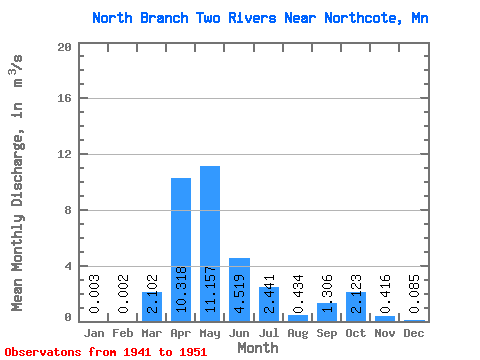
| Statistic | Jan | Feb | Mar | Apr | May | Jun | Jul | Aug | Sep | Oct | Nov | Dec | Annual |
|---|---|---|---|---|---|---|---|---|---|---|---|---|---|
| Mean | 0.00 | 0.00 | 2.10 | 10.32 | 11.16 | 4.52 | 2.44 | 0.43 | 1.31 | 2.12 | 0.42 | 0.09 | 3.16 |
| Standard Deviation | 0.01 | 0.01 | 3.29 | 6.23 | 18.28 | 6.39 | 4.10 | 0.52 | 1.70 | 3.28 | 0.47 | 0.09 | 3.58 |
| Min | 0.00 | 0.00 | 0.00 | 2.02 | 0.52 | 0.04 | 0.04 | 0.00 | 0.00 | 0.00 | 0.01 | 0.00 | 0.89 |
| Max | 0.02 | 0.01 | 8.44 | 18.73 | 58.64 | 20.36 | 11.23 | 1.28 | 5.30 | 9.79 | 1.43 | 0.26 | 9.35 |
| Coefficient of Variation | 2.65 | 2.65 | 1.56 | 0.60 | 1.64 | 1.41 | 1.68 | 1.20 | 1.30 | 1.54 | 1.12 | 1.09 | 1.13 |
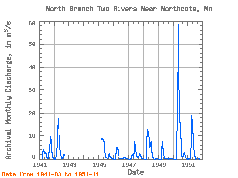
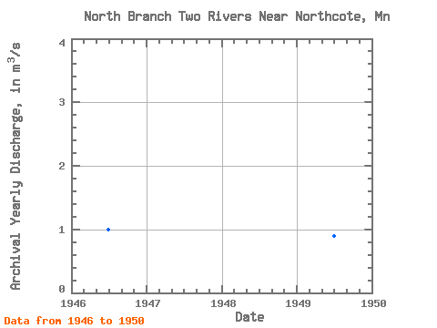
| Year | Jan | Feb | Mar | Apr | May | Jun | Jul | Aug | Sep | Oct | Nov | Dec | Annual | 1941 | 0.01 | 4.26 | 2.30 | 2.63 | 0.14 | 0.00 | 5.30 | 9.79 | 1.43 | 0.26 | 1942 | 0.00 | 0.00 | 5.68 | 17.44 | 8.96 | 2.25 | 0.09 | 0.29 | 1.78 | 1945 | 8.44 | 8.64 | 7.11 | 0.95 | 0.59 | 0.03 | 2.33 | 0.80 | 0.22 | 0.04 | 1946 | 0.00 | 0.00 | 4.78 | 4.92 | 0.52 | 0.04 | 0.04 | 0.01 | 0.60 | 0.84 | 0.17 | 0.00 | 0.99 | 1947 | 0.00 | 0.00 | 0.01 | 2.02 | 0.63 | 7.42 | 1.99 | 0.67 | 0.71 | 2.45 | 0.67 | 0.15 | 1.39 | 1948 | 0.02 | 0.00 | 0.00 | 12.95 | 11.10 | 4.94 | 7.57 | 1.28 | 0.03 | 0.00 | 0.01 | 0.01 | 3.16 | 1949 | 0.00 | 0.00 | 0.00 | 7.52 | 1.59 | 0.31 | 0.22 | 0.37 | 0.00 | 0.30 | 0.35 | 0.04 | 0.89 | 1950 | 0.00 | 0.00 | 0.00 | 16.37 | 58.64 | 20.36 | 11.23 | 1.25 | 0.99 | 2.79 | 0.47 | 0.09 | 9.35 | 1951 | 0.00 | 0.01 | 0.01 | 18.73 | 9.56 | 1.78 | 0.11 | 0.01 | 0.01 | 0.01 | 0.01 |
|---|
 Return to R-Arctic Net Home Page