|
|
|||||||||||||||||
| Point ID: 9580 | Downloads | Plots | Site Data | Code: 05131455 |
|
|
|||||||||||||||||
| Download | |
|---|---|
| Site Descriptor Information | Site Time Series Data |
| Link to all available data | |
|
|
| View: | Statistics | Time Series |
| Units: | mm |
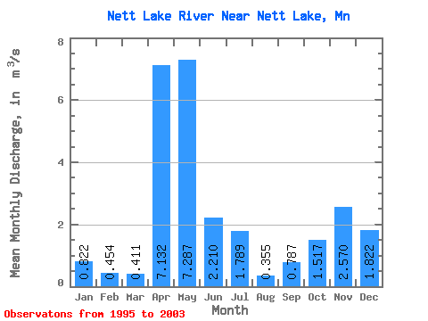
| Statistic | Jan | Feb | Mar | Apr | May | Jun | Jul | Aug | Sep | Oct | Nov | Dec | Annual |
|---|---|---|---|---|---|---|---|---|---|---|---|---|---|
| Mean | 0.82 | 0.45 | 0.41 | 7.13 | 7.29 | 2.21 | 1.79 | 0.35 | 0.79 | 1.52 | 2.57 | 1.82 | 2.36 |
| Standard Deviation | 0.66 | 0.38 | 0.45 | 4.51 | 5.63 | 1.98 | 1.40 | 0.65 | 1.60 | 1.67 | 2.62 | 1.46 | 0.86 |
| Min | 0.04 | 0.00 | 0.00 | 0.02 | 0.02 | 0.34 | 0.04 | 0.00 | 0.00 | 0.01 | 0.00 | 0.04 | 1.46 |
| Max | 1.54 | 1.05 | 1.14 | 13.14 | 14.51 | 5.99 | 4.03 | 1.80 | 4.37 | 4.34 | 5.97 | 3.61 | 3.24 |
| Coefficient of Variation | 0.80 | 0.83 | 1.09 | 0.63 | 0.77 | 0.90 | 0.79 | 1.82 | 2.04 | 1.10 | 1.02 | 0.80 | 0.36 |
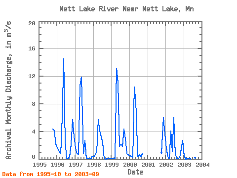
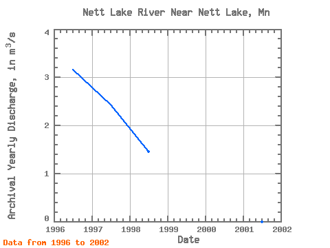
| Year | Jan | Feb | Mar | Apr | May | Jun | Jul | Aug | Sep | Oct | Nov | Dec | Annual | 1995 | 4.34 | 4.09 | 2.21 | 1996 | 1.47 | 1.05 | 0.78 | 6.09 | 14.51 | 2.54 | 0.04 | 0.07 | 0.35 | 2.14 | 5.71 | 3.23 | 3.16 | 1997 | 1.54 | 0.73 | 0.67 | 10.55 | 11.90 | 0.72 | 2.68 | 0.01 | 0.00 | 0.04 | 0.03 | 0.38 | 2.44 | 1998 | 0.32 | 0.63 | 1.14 | 5.71 | 4.04 | 3.28 | 2.33 | 0.00 | 0.00 | 0.01 | 0.00 | 0.04 | 1.46 | 1999 | 0.04 | 0.04 | 0.09 | 13.14 | 11.07 | 1.83 | 2.11 | 1.80 | 4.37 | 2.93 | 0.79 | 0.62 | 3.24 | 2000 | 0.47 | 0.37 | 0.20 | 10.40 | 8.34 | 0.34 | 0.60 | 0.29 | 0.71 | 2001 | 0.92 | 5.97 | 3.61 | 2002 | 1.51 | 0.35 | 0.00 | 4.02 | 1.14 | 5.99 | 0.72 | 0.09 | 0.05 | 0.24 | 1.41 | 2.67 | 1.52 | 2003 | 0.40 | 0.00 | 0.00 | 0.02 | 0.02 | 0.77 | 4.03 | 0.21 | 0.03 |
|---|
 Return to R-Arctic Net Home Page