|
|
|||||||||||||||||
| Point ID: 9573 | Downloads | Plots | Site Data | Code: 05035500 |
|
|
|||||||||||||||||
| Download | |
|---|---|
| Site Descriptor Information | Site Time Series Data |
| Link to all available data | |
|
|
| View: | Statistics | Time Series |
| Units: | mm |
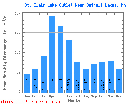
| Statistic | Jan | Feb | Mar | Apr | May | Jun | Jul | Aug | Sep | Oct | Nov | Dec | Annual |
|---|---|---|---|---|---|---|---|---|---|---|---|---|---|
| Mean | 0.09 | 0.12 | 0.18 | 0.38 | 0.33 | 0.26 | 0.15 | 0.12 | 0.15 | 0.15 | 0.16 | 0.12 | 0.18 |
| Standard Deviation | 0.05 | 0.04 | 0.06 | 0.11 | 0.15 | 0.11 | 0.05 | 0.06 | 0.10 | 0.11 | 0.09 | 0.07 | 0.04 |
| Min | 0.01 | 0.04 | 0.13 | 0.22 | 0.17 | 0.15 | 0.11 | 0.07 | 0.04 | 0.08 | 0.07 | 0.06 | 0.14 |
| Max | 0.17 | 0.16 | 0.30 | 0.49 | 0.56 | 0.41 | 0.23 | 0.21 | 0.32 | 0.36 | 0.30 | 0.23 | 0.24 |
| Coefficient of Variation | 0.58 | 0.34 | 0.35 | 0.28 | 0.45 | 0.43 | 0.32 | 0.48 | 0.72 | 0.71 | 0.55 | 0.55 | 0.21 |
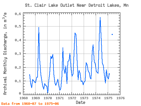
| Year | Jan | Feb | Mar | Apr | May | Jun | Jul | Aug | Sep | Oct | Nov | Dec | Annual | 1968 | 0.15 | 0.08 | 0.05 | 0.11 | 0.10 | 0.09 | 1969 | 0.09 | 0.13 | 0.13 | 0.49 | 0.26 | 0.15 | 0.11 | 0.07 | 0.04 | 0.08 | 0.07 | 0.06 | 0.14 | 1970 | 0.01 | 0.10 | 0.15 | 0.28 | 0.26 | 0.29 | 0.15 | 0.08 | 0.07 | 0.09 | 0.11 | 0.07 | 0.14 | 1971 | 0.03 | 0.04 | 0.14 | 0.34 | 0.19 | 0.15 | 0.21 | 0.08 | 0.24 | 0.25 | 0.30 | 0.19 | 0.18 | 1972 | 0.13 | 0.15 | 0.30 | 0.45 | 0.44 | 0.27 | 0.11 | 0.18 | 0.15 | 0.10 | 0.10 | 0.07 | 0.20 | 1973 | 0.09 | 0.10 | 0.23 | 0.22 | 0.17 | 0.16 | 0.12 | 0.12 | 0.32 | 0.36 | 0.24 | 0.23 | 0.20 | 1974 | 0.17 | 0.16 | 0.16 | 0.42 | 0.56 | 0.39 | 0.23 | 0.21 | 0.15 | 0.08 | 0.18 | 0.13 | 0.24 | 1975 | 0.11 | 0.15 | 0.15 | 0.48 | 0.44 | 0.41 |
|---|
 Return to R-Arctic Net Home Page