|
|
|||||||||||||||||
| Point ID: 9572 | Downloads | Plots | Site Data | Code: 05127207 |
|
|
|||||||||||||||||
| Download | |
|---|---|
| Site Descriptor Information | Site Time Series Data |
| Link to all available data | |
|
|
| View: | Statistics | Time Series |
| Units: | mm |
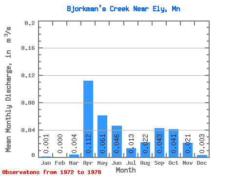
| Statistic | Jan | Feb | Mar | Apr | May | Jun | Jul | Aug | Sep | Oct | Nov | Dec | Annual |
|---|---|---|---|---|---|---|---|---|---|---|---|---|---|
| Mean | 0.00 | 0.00 | 0.00 | 0.11 | 0.06 | 0.05 | 0.01 | 0.02 | 0.04 | 0.04 | 0.02 | 0.00 | 0.03 |
| Standard Deviation | 0.00 | 0.00 | 0.01 | 0.06 | 0.03 | 0.02 | 0.01 | 0.03 | 0.07 | 0.06 | 0.02 | 0.01 | 0.01 |
| Min | 0.00 | 0.00 | 0.00 | 0.01 | 0.01 | 0.02 | 0.00 | 0.00 | 0.00 | 0.00 | 0.00 | 0.00 | 0.02 |
| Max | 0.00 | 0.00 | 0.02 | 0.17 | 0.10 | 0.06 | 0.02 | 0.06 | 0.19 | 0.14 | 0.05 | 0.01 | 0.04 |
| Coefficient of Variation | 1.27 | 2.45 | 1.86 | 0.56 | 0.55 | 0.34 | 0.68 | 1.10 | 1.56 | 1.40 | 0.97 | 1.65 | 0.30 |
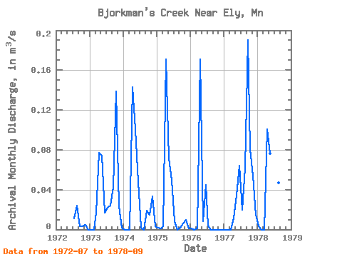
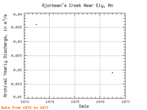
| Year | Jan | Feb | Mar | Apr | May | Jun | Jul | Aug | Sep | Oct | Nov | Dec | Annual | 1972 | 0.01 | 0.02 | 0.00 | 0.00 | 0.01 | 0.00 | 1973 | 0.00 | 0.00 | 0.02 | 0.08 | 0.07 | 0.02 | 0.02 | 0.02 | 0.04 | 0.14 | 0.02 | 0.00 | 0.04 | 1974 | 0.00 | 0.00 | 0.00 | 0.14 | 0.10 | 0.05 | 0.00 | 0.00 | 0.02 | 0.01 | 0.03 | 0.00 | 0.03 | 1975 | 0.00 | 0.00 | 0.00 | 0.17 | 0.07 | 0.05 | 0.01 | 0.00 | 0.00 | 0.01 | 0.01 | 0.00 | 0.03 | 1976 | 0.00 | 0.00 | 0.00 | 0.17 | 0.01 | 0.04 | 0.00 | 0.00 | 0.00 | 0.00 | 0.00 | 0.00 | 0.02 | 1977 | 0.00 | 0.00 | 0.00 | 0.01 | 0.03 | 0.06 | 0.02 | 0.06 | 0.19 | 0.08 | 0.05 | 0.01 | 0.04 | 1978 | 0.00 | 0.00 | 0.00 | 0.10 | 0.08 | 0.05 | 0.02 | 0.05 | 0.05 |
|---|
 Return to R-Arctic Net Home Page