|
|
|||||||||||||||||
| Point ID: 9550 | Downloads | Plots | Site Data | Code: 05128340 |
|
|
|||||||||||||||||
| Download | |
|---|---|
| Site Descriptor Information | Site Time Series Data |
| Link to all available data | |
|
|
| View: | Statistics | Time Series |
| Units: | mm |
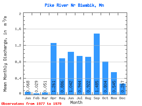
| Statistic | Jan | Feb | Mar | Apr | May | Jun | Jul | Aug | Sep | Oct | Nov | Dec | Annual |
|---|---|---|---|---|---|---|---|---|---|---|---|---|---|
| Mean | 0.07 | 0.03 | 0.05 | 1.26 | 0.89 | 1.04 | 0.94 | 0.92 | 1.48 | 0.80 | 0.55 | 0.27 | 0.69 |
| Standard Deviation | 0.08 | 0.03 | 0.02 | 1.63 | 1.03 | 0.78 | 1.02 | 0.86 | 0.51 | 0.81 | 0.55 | 0.23 | 0.28 |
| Min | 0.00 | 0.00 | 0.04 | 0.11 | 0.16 | 0.49 | 0.22 | 0.32 | 1.13 | 0.23 | 0.16 | 0.11 | 0.49 |
| Max | 0.15 | 0.05 | 0.06 | 2.41 | 1.61 | 1.59 | 1.67 | 1.53 | 1.84 | 1.38 | 0.93 | 0.43 | 0.89 |
| Coefficient of Variation | 1.13 | 0.87 | 0.33 | 1.29 | 1.16 | 0.75 | 1.08 | 0.93 | 0.34 | 1.01 | 1.01 | 0.85 | 0.40 |
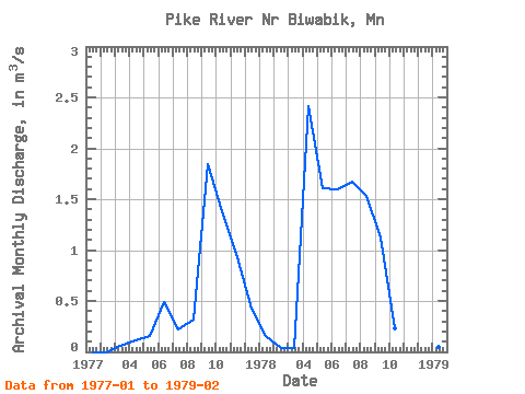
| Year | Jan | Feb | Mar | Apr | May | Jun | Jul | Aug | Sep | Oct | Nov | Dec | Annual | 1977 | 0.00 | 0.00 | 0.06 | 0.11 | 0.16 | 0.49 | 0.22 | 0.32 | 1.84 | 1.38 | 0.93 | 0.43 | 0.49 | 1978 | 0.15 | 0.04 | 0.04 | 2.41 | 1.61 | 1.59 | 1.67 | 1.53 | 1.13 | 0.23 | 0.16 | 0.11 | 0.89 | 1979 | 0.05 | 0.05 |
|---|
 Return to R-Arctic Net Home Page