|
|
|||||||||||||||||
| Point ID: 9547 | Downloads | Plots | Site Data | Code: 05078770 |
|
|
|||||||||||||||||
| Download | |
|---|---|
| Site Descriptor Information | Site Time Series Data |
| Link to all available data | |
|
|
| View: | Statistics | Time Series |
| Units: | mm |
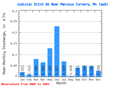
| Statistic | Jan | Feb | Mar | Apr | May | Jun | Jul | Aug | Sep | Oct | Nov | Dec | Annual |
|---|---|---|---|---|---|---|---|---|---|---|---|---|---|
| Mean | 0.02 | 0.01 | 0.08 | 0.07 | 0.13 | 0.23 | 0.07 | 0.00 | 0.04 | 0.05 | 0.05 | 0.03 | |
| Standard Deviation | 0.05 | ||||||||||||
| Min | 0.02 | 0.01 | 0.08 | 0.07 | 0.13 | 0.23 | 0.07 | 0.00 | 0.01 | 0.05 | 0.05 | 0.03 | |
| Max | 0.02 | 0.01 | 0.08 | 0.07 | 0.13 | 0.23 | 0.07 | 0.00 | 0.08 | 0.05 | 0.05 | 0.03 | |
| Coefficient of Variation | 1.19 |
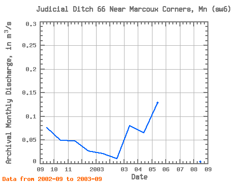
| Year | Jan | Feb | Mar | Apr | May | Jun | Jul | Aug | Sep | Oct | Nov | Dec | Annual | 2002 | 0.08 | 0.05 | 0.05 | 0.03 | 2003 | 0.02 | 0.01 | 0.08 | 0.07 | 0.13 | 0.23 | 0.07 | 0.00 | 0.01 |
|---|
 Return to R-Arctic Net Home Page