|
|
|||||||||||||||||
| Point ID: 9527 | Downloads | Plots | Site Data | Code: 15283700 |
|
|
|||||||||||||||||
| Download | |
|---|---|
| Site Descriptor Information | Site Time Series Data |
| Link to all available data | |
|
|
| View: | Statistics | Time Series |
| Units: | mm |
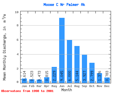
| Statistic | Jan | Feb | Mar | Apr | May | Jun | Jul | Aug | Sep | Oct | Nov | Dec | Annual |
|---|---|---|---|---|---|---|---|---|---|---|---|---|---|
| Mean | 0.61 | 0.52 | 0.47 | 0.81 | 2.23 | 9.04 | 6.00 | 5.14 | 3.93 | 2.80 | 1.38 | 0.78 | 3.05 |
| Standard Deviation | 0.07 | 0.10 | 0.08 | 0.21 | 0.33 | 1.87 | 2.22 | 0.74 | 1.92 | 0.29 | 0.27 | 0.11 | 0.73 |
| Min | 0.54 | 0.41 | 0.40 | 0.57 | 1.88 | 7.36 | 4.31 | 4.18 | 2.43 | 2.48 | 1.07 | 0.70 | 2.53 |
| Max | 0.69 | 0.59 | 0.55 | 0.97 | 2.55 | 10.89 | 9.27 | 5.95 | 6.70 | 3.02 | 1.57 | 0.91 | 3.57 |
| Coefficient of Variation | 0.12 | 0.18 | 0.16 | 0.26 | 0.15 | 0.21 | 0.37 | 0.14 | 0.49 | 0.10 | 0.20 | 0.14 | 0.24 |
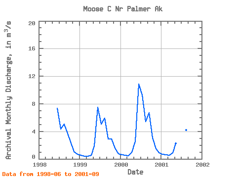
| Year | Jan | Feb | Mar | Apr | May | Jun | Jul | Aug | Sep | Oct | Nov | Dec | Annual | 1998 | 7.36 | 4.31 | 5.07 | 3.69 | 2.48 | 1.07 | 0.70 | 1999 | 0.54 | 0.41 | 0.40 | 0.57 | 1.88 | 7.51 | 5.04 | 5.95 | 2.89 | 2.90 | 1.57 | 0.73 | 2.53 | 2000 | 0.62 | 0.57 | 0.47 | 0.97 | 2.55 | 10.89 | 9.27 | 5.38 | 6.70 | 3.02 | 1.49 | 0.91 | 3.57 | 2001 | 0.69 | 0.59 | 0.55 | 0.90 | 2.26 | 10.41 | 5.37 | 4.18 | 2.43 |
|---|
 Return to R-Arctic Net Home Page