|
|
|||||||||||||||||
| Point ID: 9523 | Downloads | Plots | Site Data | Code: 15292780 |
|
|
|||||||||||||||||
| Download | |
|---|---|
| Site Descriptor Information | Site Time Series Data |
| Link to all available data | |
|
|
| View: | Statistics | Time Series |
| Units: | mm |
| Statistic | Jan | Feb | Mar | Apr | May | Jun | Jul | Aug | Sep | Oct | Nov | Dec | Annual |
|---|---|---|---|---|---|---|---|---|---|---|---|---|---|
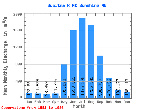
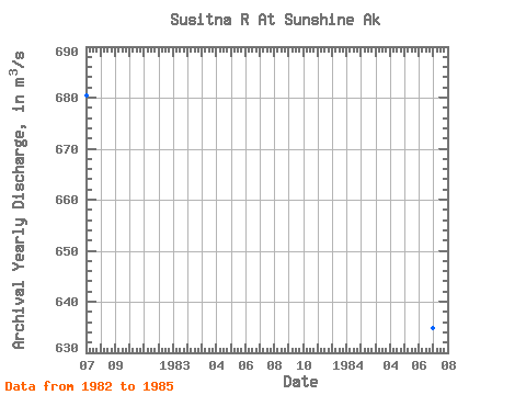
| Mean | 123.88 | 111.53 | 99.00 | 111.80 | 792.03 | 1599.05 | 1875.58 | 1726.54 | 996.79 | 470.06 | 192.18 | 138.11 | 672.09 |
| Standard Deviation | 21.20 | 18.97 | 19.16 | 15.43 | 141.62 | 176.18 | 334.05 | 413.22 | 275.16 | 90.30 | 25.70 | 20.20 | 25.56 |
| Min | 99.11 | 91.42 | 81.48 | 87.78 | 624.07 | 1327.21 | 1568.11 | 1290.88 | 678.09 | 349.76 | 172.07 | 114.27 | 634.85 |
| Max | 147.70 | 132.08 | 127.33 | 128.94 | 1023.97 | 1778.96 | 2423.83 | 2405.29 | 1382.71 | 604.15 | 234.28 | 158.94 | 693.11 |
| Coefficient of Variation | 0.17 | 0.17 | 0.19 | 0.14 | 0.18 | 0.11 | 0.18 | 0.24 | 0.28 | 0.19 | 0.13 | 0.15 | 0.04 |
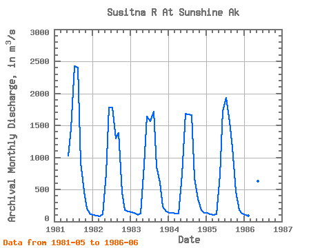
| Year | Jan | Feb | Mar | Apr | May | Jun | Jul | Aug | Sep | Oct | Nov | Dec | Annual | 1981 | 1023.97 | 1440.95 | 2423.83 | 2405.29 | 919.16 | 465.86 | 199.07 | 114.27 | 1982 | 99.11 | 91.42 | 81.48 | 107.70 | 752.13 | 1778.96 | 1784.78 | 1290.88 | 1382.71 | 458.17 | 178.40 | 158.94 | 680.39 | 1983 | 147.70 | 132.08 | 98.56 | 118.84 | 888.78 | 1645.11 | 1568.11 | 1715.45 | 849.88 | 604.15 | 234.28 | 157.30 | 680.02 | 1984 | 138.66 | 130.26 | 127.33 | 128.94 | 734.01 | 1678.53 | 1674.62 | 1662.84 | 678.09 | 349.76 | 177.07 | 138.11 | 634.85 | 1985 | 129.25 | 108.21 | 106.14 | 115.72 | 729.21 | 1723.55 | 1926.55 | 1558.25 | 1154.10 | 472.34 | 172.07 | 121.94 | 693.11 | 1986 | 104.68 | 95.67 | 81.48 | 87.78 | 624.07 | 1327.21 |
|---|
 Return to R-Arctic Net Home Page