|
|
|||||||||||||||||
| Point ID: 9522 | Downloads | Plots | Site Data | Code: 15292400 |
|
|
|||||||||||||||||
| Download | |
|---|---|
| Site Descriptor Information | Site Time Series Data |
| Link to all available data | |
|
|
| View: | Statistics | Time Series |
| Units: | mm |
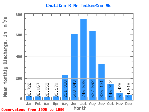
| Statistic | Jan | Feb | Mar | Apr | May | Jun | Jul | Aug | Sep | Oct | Nov | Dec | Annual |
|---|---|---|---|---|---|---|---|---|---|---|---|---|---|
| Mean | 38.72 | 32.07 | 28.35 | 33.17 | 231.34 | 608.05 | 746.53 | 637.59 | 335.13 | 146.91 | 61.43 | 44.62 | 247.41 |
| Standard Deviation | 8.31 | 5.35 | 4.51 | 6.48 | 82.48 | 148.13 | 107.42 | 134.86 | 102.59 | 40.14 | 14.03 | 10.40 | 26.54 |
| Min | 27.59 | 23.22 | 20.91 | 19.82 | 66.68 | 416.63 | 589.63 | 320.11 | 189.83 | 82.06 | 41.91 | 28.32 | 177.45 |
| Max | 57.91 | 42.67 | 36.81 | 45.31 | 393.41 | 1142.11 | 1007.26 | 953.55 | 630.43 | 244.04 | 90.99 | 67.59 | 309.01 |
| Coefficient of Variation | 0.21 | 0.17 | 0.16 | 0.20 | 0.36 | 0.24 | 0.14 | 0.21 | 0.31 | 0.27 | 0.23 | 0.23 | 0.11 |
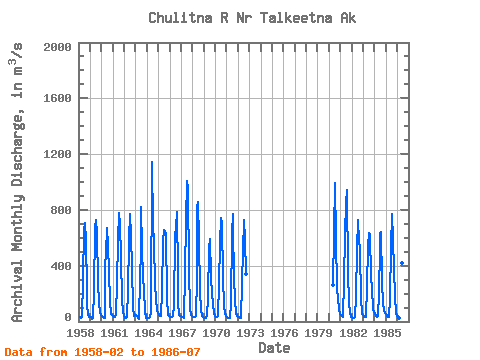
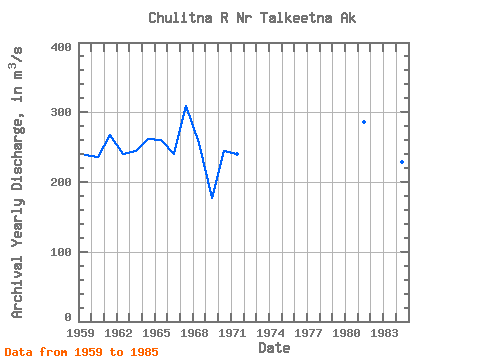
| Year | Jan | Feb | Mar | Apr | May | Jun | Jul | Aug | Sep | Oct | Nov | Dec | Annual | 1958 | 29.57 | 26.86 | 34.55 | 296.19 | 656.10 | 708.29 | 587.80 | 226.53 | 118.86 | 53.32 | 35.73 | 1959 | 31.06 | 29.70 | 20.91 | 25.20 | 209.91 | 669.88 | 726.37 | 625.80 | 281.96 | 133.74 | 64.66 | 48.14 | 238.94 | 1960 | 41.01 | 31.25 | 26.43 | 28.32 | 393.41 | 492.52 | 669.74 | 547.15 | 351.80 | 145.41 | 55.22 | 49.42 | 235.97 | 1961 | 41.10 | 31.15 | 30.55 | 45.31 | 286.00 | 580.21 | 776.34 | 695.96 | 454.00 | 163.58 | 67.96 | 42.48 | 267.89 | 1962 | 36.81 | 28.32 | 26.34 | 33.13 | 219.26 | 583.99 | 770.77 | 622.42 | 382.09 | 99.28 | 42.48 | 43.94 | 240.74 | 1963 | 45.31 | 36.81 | 23.96 | 19.82 | 313.31 | 502.53 | 819.73 | 520.66 | 320.92 | 228.29 | 65.13 | 28.32 | 243.73 | 1964 | 28.52 | 23.22 | 21.80 | 32.09 | 66.68 | 1142.11 | 691.84 | 573.46 | 261.50 | 159.77 | 82.12 | 59.47 | 261.88 | 1965 | 45.31 | 39.64 | 36.81 | 39.64 | 211.01 | 568.32 | 657.77 | 638.50 | 630.43 | 171.91 | 45.87 | 38.23 | 260.29 | 1966 | 33.98 | 31.15 | 31.15 | 36.81 | 112.45 | 615.51 | 672.48 | 784.92 | 345.45 | 132.59 | 47.57 | 42.48 | 240.54 | 1967 | 41.29 | 35.60 | 29.60 | 27.51 | 351.13 | 722.74 | 1007.26 | 953.55 | 354.31 | 98.63 | 47.01 | 39.55 | 309.01 | 1968 | 34.98 | 33.98 | 32.52 | 38.13 | 309.76 | 821.28 | 853.43 | 586.52 | 208.84 | 82.06 | 41.91 | 32.24 | 256.31 | 1969 | 27.59 | 25.48 | 23.34 | 37.76 | 169.92 | 525.43 | 589.63 | 320.11 | 189.83 | 129.65 | 53.42 | 37.27 | 177.45 | 1970 | 33.98 | 32.67 | 31.15 | 40.68 | 273.05 | 556.90 | 739.16 | 698.24 | 320.93 | 108.33 | 62.58 | 39.73 | 244.78 | 1971 | 31.51 | 26.90 | 26.44 | 27.80 | 126.51 | 628.07 | 772.50 | 674.22 | 313.76 | 154.01 | 61.07 | 40.56 | 240.28 | 1972 | 33.25 | 29.49 | 26.58 | 25.30 | 276.50 | 506.78 | 729.84 | 593.83 | 343.09 | 1980 | 258.87 | 636.75 | 989.63 | 588.53 | 233.32 | 161.71 | 90.99 | 57.09 | 1981 | 45.95 | 40.05 | 33.16 | 40.78 | 282.37 | 634.77 | 845.58 | 939.21 | 338.71 | 136.72 | 63.81 | 34.53 | 286.30 | 1982 | 29.18 | 24.73 | 22.33 | 30.35 | 178.08 | 519.80 | 725.18 | 576.66 | 516.40 | 155.71 | 71.17 | 52.48 | 241.84 | 1983 | 44.53 | 29.43 | 29.73 | 35.35 | 251.47 | 534.90 | 632.01 | 628.36 | 310.49 | 244.04 | 82.78 | 67.59 | 240.89 | 1984 | 57.91 | 42.67 | 35.62 | 38.98 | 207.13 | 526.65 | 630.74 | 644.99 | 280.92 | 133.82 | 75.70 | 61.20 | 228.03 | 1985 | 53.89 | 39.54 | 32.98 | 32.00 | 161.77 | 535.19 | 768.66 | 588.53 | 372.48 | 180.13 | 53.80 | 41.93 | 238.41 | 1986 | 37.27 | 32.06 | 27.16 | 27.06 | 134.64 | 416.63 | 646.81 |
|---|
 Return to R-Arctic Net Home Page