|
|
|||||||||||||||||
| Point ID: 9515 | Downloads | Plots | Site Data | Code: 15284000 |
|
|
|||||||||||||||||
| Download | |
|---|---|
| Site Descriptor Information | Site Time Series Data |
| Link to all available data | |
|
|
| View: | Statistics | Time Series |
| Units: | mm |
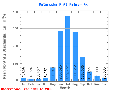
| Statistic | Jan | Feb | Mar | Apr | May | Jun | Jul | Aug | Sep | Oct | Nov | Dec | Annual |
|---|---|---|---|---|---|---|---|---|---|---|---|---|---|
| Mean | 17.61 | 14.72 | 13.41 | 18.25 | 78.74 | 286.62 | 370.43 | 280.61 | 136.04 | 54.62 | 27.89 | 20.64 | 110.09 |
| Standard Deviation | 3.19 | 1.87 | 1.68 | 3.84 | 34.29 | 87.48 | 60.94 | 59.09 | 44.00 | 14.72 | 8.15 | 4.32 | 14.40 |
| Min | 9.87 | 10.78 | 10.19 | 13.17 | 28.52 | 153.34 | 260.69 | 141.36 | 60.11 | 33.03 | 16.09 | 12.46 | 72.44 |
| Max | 23.25 | 17.82 | 16.50 | 27.90 | 170.44 | 488.37 | 530.89 | 445.41 | 253.88 | 87.57 | 50.78 | 29.00 | 138.54 |
| Coefficient of Variation | 0.18 | 0.13 | 0.12 | 0.21 | 0.43 | 0.30 | 0.17 | 0.21 | 0.32 | 0.27 | 0.29 | 0.21 | 0.13 |
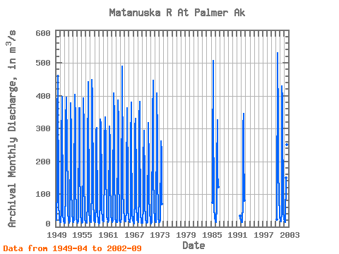
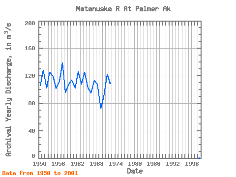
| Year | Jan | Feb | Mar | Apr | May | Jun | Jul | Aug | Sep | Oct | Nov | Dec | Annual | 1949 | 19.77 | 123.71 | 319.99 | 461.73 | 347.99 | 180.33 | 66.12 | 33.08 | 22.86 | 1950 | 17.01 | 13.74 | 14.02 | 16.96 | 46.09 | 251.91 | 397.81 | 314.44 | 123.96 | 36.80 | 18.69 | 16.42 | 105.65 | 1951 | 14.16 | 12.74 | 11.35 | 22.55 | 101.25 | 319.67 | 394.85 | 260.09 | 253.88 | 82.77 | 35.55 | 26.73 | 127.96 | 1952 | 22.44 | 14.16 | 12.39 | 15.10 | 45.23 | 239.44 | 378.39 | 279.02 | 93.69 | 66.85 | 36.92 | 23.22 | 102.24 | 1953 | 15.86 | 13.03 | 13.03 | 23.14 | 107.27 | 399.67 | 402.83 | 322.54 | 123.47 | 44.42 | 22.37 | 17.56 | 125.43 | 1954 | 16.14 | 12.74 | 11.89 | 16.97 | 89.66 | 265.49 | 362.97 | 361.71 | 173.04 | 69.22 | 30.18 | 21.80 | 119.32 | 1955 | 19.25 | 14.88 | 12.38 | 13.65 | 50.45 | 196.78 | 391.60 | 296.50 | 141.24 | 44.00 | 20.30 | 16.40 | 101.45 | 1956 | 14.72 | 12.92 | 11.33 | 14.22 | 73.94 | 217.27 | 442.20 | 304.31 | 168.79 | 46.05 | 19.54 | 18.43 | 111.98 | 1957 | 18.68 | 16.64 | 14.74 | 20.46 | 119.94 | 448.97 | 396.44 | 309.81 | 199.42 | 66.67 | 32.50 | 18.26 | 138.54 | 1958 | 18.70 | 15.09 | 13.79 | 25.23 | 60.02 | 294.78 | 302.06 | 255.66 | 90.23 | 41.09 | 16.09 | 13.42 | 95.51 | 1959 | 9.87 | 12.48 | 11.34 | 16.08 | 79.74 | 327.95 | 301.65 | 319.08 | 120.61 | 50.77 | 27.62 | 20.26 | 108.12 | 1960 | 18.95 | 16.42 | 15.95 | 19.89 | 170.44 | 251.62 | 335.30 | 255.41 | 156.79 | 70.57 | 29.99 | 23.67 | 113.75 | 1961 | 23.25 | 17.77 | 13.58 | 19.70 | 74.78 | 269.06 | 306.97 | 256.30 | 132.08 | 57.04 | 31.15 | 24.35 | 102.17 | 1962 | 21.52 | 16.14 | 13.88 | 20.22 | 69.24 | 397.62 | 408.04 | 333.08 | 142.78 | 48.95 | 24.62 | 17.76 | 126.15 | 1963 | 17.03 | 16.33 | 14.02 | 14.90 | 107.27 | 189.66 | 386.07 | 317.76 | 138.37 | 57.00 | 17.43 | 17.80 | 107.80 | 1964 | 15.66 | 15.01 | 15.01 | 27.90 | 45.98 | 488.37 | 353.65 | 317.46 | 116.23 | 49.95 | 32.06 | 20.45 | 124.81 | 1965 | 21.41 | 15.51 | 16.20 | 23.53 | 43.20 | 153.34 | 362.18 | 265.85 | 221.14 | 54.72 | 26.80 | 24.43 | 102.36 | 1966 | 18.43 | 15.68 | 13.88 | 18.38 | 28.52 | 257.82 | 379.35 | 215.41 | 108.00 | 44.01 | 20.79 | 17.96 | 94.85 | 1967 | 15.93 | 13.47 | 10.30 | 15.81 | 89.40 | 302.10 | 331.01 | 308.03 | 162.59 | 54.40 | 31.05 | 21.39 | 112.96 | 1968 | 19.97 | 17.48 | 15.58 | 15.03 | 105.31 | 325.67 | 380.73 | 264.89 | 83.94 | 37.30 | 16.23 | 12.46 | 107.88 | 1969 | 12.46 | 12.46 | 12.46 | 14.88 | 60.84 | 191.06 | 292.80 | 141.36 | 60.11 | 33.12 | 21.11 | 16.68 | 72.44 | 1970 | 14.22 | 12.95 | 12.45 | 13.46 | 80.48 | 232.40 | 317.17 | 190.45 | 90.13 | 46.77 | 37.28 | 25.30 | 89.42 | 1971 | 15.69 | 10.78 | 10.19 | 13.89 | 28.76 | 303.77 | 336.68 | 445.41 | 141.48 | 81.66 | 50.78 | 29.00 | 122.34 | 1972 | 19.46 | 16.36 | 13.98 | 13.17 | 90.72 | 241.03 | 407.21 | 273.75 | 139.48 | 56.89 | 25.48 | 15.30 | 109.40 | 1973 | 14.16 | 14.00 | 13.21 | 19.76 | 48.49 | 216.72 | 260.69 | 227.80 | 69.44 | 1985 | 74.33 | 209.51 | 507.24 | 251.99 | 165.87 | 55.09 | 30.25 | 26.72 | 1986 | 19.27 | 16.71 | 14.66 | 16.91 | 59.16 | 183.11 | 326.23 | 169.87 | 122.13 | 1991 | 33.03 | 23.83 | 20.42 | 1992 | 18.09 | 13.42 | 13.19 | 15.21 | 67.29 | 305.26 | 344.10 | 239.59 | 80.37 | 2000 | 22.88 | 110.20 | 441.72 | 530.89 | 313.92 | 179.24 | 87.57 | 41.42 | 27.22 | 2001 | 22.39 | 17.82 | 16.50 | 19.80 | 40.64 | 427.97 | 385.69 | 288.64 | 119.56 | 46.59 | 27.80 | 21.51 | 119.58 | 2002 | 18.32 | 15.57 | 14.10 | 18.09 | 148.66 | 215.63 | 298.73 | 250.86 | 118.74 |
|---|
 Return to R-Arctic Net Home Page