|
|
|||||||||||||||||
| Point ID: 9499 | Downloads | Plots | Site Data | Code: 15297100 |
|
|
|||||||||||||||||
| Download | |
|---|---|
| Site Descriptor Information | Site Time Series Data |
| Link to all available data | |
|
|
| View: | Statistics | Time Series |
| Units: | mm |
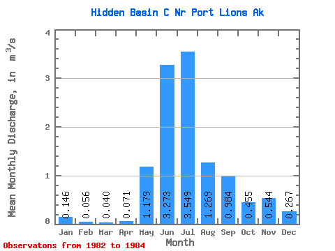
| Statistic | Jan | Feb | Mar | Apr | May | Jun | Jul | Aug | Sep | Oct | Nov | Dec | Annual |
|---|---|---|---|---|---|---|---|---|---|---|---|---|---|
| Mean | 0.15 | 0.06 | 0.04 | 0.07 | 1.18 | 3.27 | 3.55 | 1.27 | 0.98 | 0.46 | 0.54 | 0.27 | 1.06 |
| Standard Deviation | 0.01 | 0.80 | 0.42 | 0.37 | 0.51 | 0.00 | |||||||
| Min | 0.14 | 0.06 | 0.04 | 0.07 | 1.18 | 3.27 | 3.55 | 0.70 | 0.69 | 0.19 | 0.18 | 0.26 | 1.06 |
| Max | 0.16 | 0.06 | 0.04 | 0.07 | 1.18 | 3.27 | 3.55 | 1.84 | 1.28 | 0.71 | 0.91 | 0.27 | 1.06 |
| Coefficient of Variation | 0.09 | 0.63 | 0.43 | 0.81 | 0.94 | 0.02 |
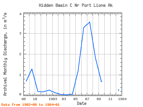
| Year | Jan | Feb | Mar | Apr | May | Jun | Jul | Aug | Sep | Oct | Nov | Dec | Annual | 1982 | 0.70 | 1.28 | 0.19 | 0.18 | 0.26 | 1983 | 0.14 | 0.06 | 0.04 | 0.07 | 1.18 | 3.27 | 3.55 | 1.84 | 0.69 | 0.71 | 0.91 | 0.27 | 1.06 | 1984 | 0.16 |
|---|
 Return to R-Arctic Net Home Page