|
|
|||||||||||||||||
| Point ID: 9493 | Downloads | Plots | Site Data | Code: 15296500 |
|
|
|||||||||||||||||
| Download | |
|---|---|
| Site Descriptor Information | Site Time Series Data |
| Link to all available data | |
|
|
| View: | Statistics | Time Series |
| Units: | mm |
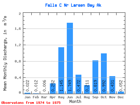
| Statistic | Jan | Feb | Mar | Apr | May | Jun | Jul | Aug | Sep | Oct | Nov | Dec | Annual |
|---|---|---|---|---|---|---|---|---|---|---|---|---|---|
| Mean | 0.02 | 0.01 | 0.01 | 0.25 | 1.15 | 1.75 | 0.47 | 0.21 | 0.82 | 0.99 | 0.43 | 0.05 | |
| Standard Deviation | 0.54 | 0.07 | 0.20 | ||||||||||
| Min | 0.02 | 0.01 | 0.01 | 0.25 | 1.15 | 1.75 | 0.09 | 0.16 | 0.68 | 0.99 | 0.43 | 0.05 | |
| Max | 0.02 | 0.01 | 0.01 | 0.25 | 1.15 | 1.75 | 0.85 | 0.26 | 0.96 | 0.99 | 0.43 | 0.05 | |
| Coefficient of Variation | 1.15 | 0.35 | 0.25 |
| Year | Jan | Feb | Mar | Apr | May | Jun | Jul | Aug | Sep | Oct | Nov | Dec | Annual | 1974 | 0.09 | 0.26 | 0.96 | 0.99 | 0.43 | 0.05 | 1975 | 0.02 | 0.01 | 0.01 | 0.25 | 1.15 | 1.75 | 0.85 | 0.16 | 0.68 |
|---|
 Return to R-Arctic Net Home Page