|
|
|||||||||||||||||
| Point ID: 9434 | Downloads | Plots | Site Data | Code: 15267000 |
|
|
|||||||||||||||||
| Download | |
|---|---|
| Site Descriptor Information | Site Time Series Data |
| Link to all available data | |
|
|
| View: | Statistics | Time Series |
| Units: | mm |
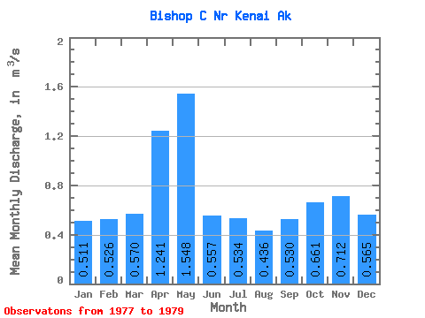
| Statistic | Jan | Feb | Mar | Apr | May | Jun | Jul | Aug | Sep | Oct | Nov | Dec | Annual |
|---|---|---|---|---|---|---|---|---|---|---|---|---|---|
| Mean | 0.51 | 0.53 | 0.57 | 1.24 | 1.55 | 0.56 | 0.53 | 0.44 | 0.53 | 0.66 | 0.71 | 0.56 | 0.62 |
| Standard Deviation | 0.08 | 0.04 | 0.12 | 0.32 | 0.77 | 0.17 | 0.11 | 0.09 | 0.06 | 0.16 | 0.19 | 0.27 | |
| Min | 0.45 | 0.49 | 0.46 | 1.01 | 0.73 | 0.36 | 0.40 | 0.35 | 0.47 | 0.55 | 0.58 | 0.37 | 0.62 |
| Max | 0.57 | 0.56 | 0.70 | 1.61 | 2.26 | 0.67 | 0.61 | 0.53 | 0.59 | 0.77 | 0.85 | 0.76 | 0.62 |
| Coefficient of Variation | 0.16 | 0.09 | 0.22 | 0.26 | 0.50 | 0.31 | 0.21 | 0.21 | 0.12 | 0.24 | 0.27 | 0.48 |
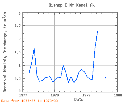
| Year | Jan | Feb | Mar | Apr | May | Jun | Jul | Aug | Sep | Oct | Nov | Dec | Annual | 1977 | 0.70 | 1.10 | 1.65 | 0.64 | 0.40 | 0.42 | 0.53 | 0.55 | 0.58 | 0.37 | 1978 | 0.45 | 0.56 | 0.55 | 1.01 | 0.73 | 0.36 | 0.58 | 0.35 | 0.47 | 0.77 | 0.85 | 0.76 | 0.62 | 1979 | 0.57 | 0.49 | 0.46 | 1.61 | 2.26 | 0.67 | 0.61 | 0.53 | 0.59 |
|---|
 Return to R-Arctic Net Home Page