|
|
|||||||||||||||||
| Point ID: 9407 | Downloads | Plots | Site Data | Code: 15297450 |
|
|
|||||||||||||||||
| Download | |
|---|---|
| Site Descriptor Information | Site Time Series Data |
| Link to all available data | |
|
|
| View: | Statistics | Time Series |
| Units: | mm |
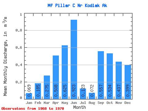
| Statistic | Jan | Feb | Mar | Apr | May | Jun | Jul | Aug | Sep | Oct | Nov | Dec | Annual |
|---|---|---|---|---|---|---|---|---|---|---|---|---|---|
| Mean | 0.07 | 0.18 | 0.28 | 0.51 | 0.62 | 0.92 | 0.12 | 0.07 | 0.56 | 0.53 | 0.44 | 0.40 | 0.46 |
| Standard Deviation | 0.06 | 0.21 | 0.25 | 0.27 | 0.39 | 0.51 | 0.03 | 0.51 | |||||
| Min | 0.02 | 0.04 | 0.10 | 0.32 | 0.35 | 0.92 | 0.12 | 0.07 | 0.56 | 0.17 | 0.42 | 0.04 | 0.46 |
| Max | 0.11 | 0.33 | 0.45 | 0.70 | 0.90 | 0.92 | 0.12 | 0.07 | 0.56 | 0.89 | 0.46 | 0.76 | 0.46 |
| Coefficient of Variation | 0.92 | 1.13 | 0.92 | 0.53 | 0.62 | 0.95 | 0.07 | 1.27 |
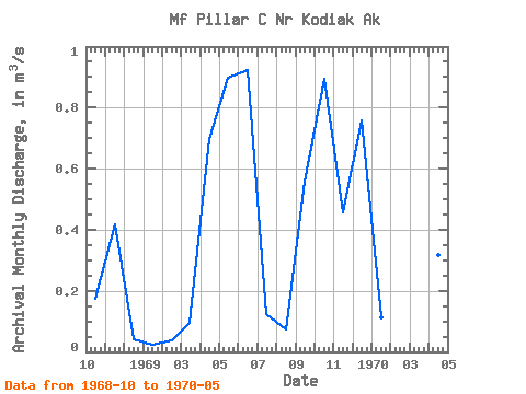
| Year | Jan | Feb | Mar | Apr | May | Jun | Jul | Aug | Sep | Oct | Nov | Dec | Annual | 1968 | 0.17 | 0.42 | 0.04 | 1969 | 0.02 | 0.04 | 0.10 | 0.70 | 0.90 | 0.92 | 0.12 | 0.07 | 0.56 | 0.89 | 0.46 | 0.76 | 0.46 | 1970 | 0.11 | 0.33 | 0.45 | 0.32 | 0.35 |
|---|
 Return to R-Arctic Net Home Page