|
|
|||||||||||||||||
| Point ID: 9406 | Downloads | Plots | Site Data | Code: 15518020 |
|
|
|||||||||||||||||
| Download | |
|---|---|
| Site Descriptor Information | Site Time Series Data |
| Link to all available data | |
|
|
| View: | Statistics | Time Series |
| Units: | mm |
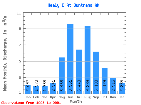
| Statistic | Jan | Feb | Mar | Apr | May | Jun | Jul | Aug | Sep | Oct | Nov | Dec | Annual |
|---|---|---|---|---|---|---|---|---|---|---|---|---|---|
| Mean | 2.09 | 1.97 | 1.96 | 2.34 | 5.46 | 9.55 | 6.45 | 9.29 | 6.18 | 4.13 | 2.92 | 2.33 | 4.51 |
| Standard Deviation | 0.62 | 0.63 | 0.43 | 0.37 | 1.99 | 1.85 | 1.38 | 4.84 | 2.55 | 2.02 | 1.14 | 0.65 | 1.32 |
| Min | 1.69 | 1.52 | 1.59 | 2.09 | 3.20 | 7.70 | 5.40 | 5.28 | 3.88 | 2.41 | 1.92 | 1.75 | 3.57 |
| Max | 2.81 | 2.69 | 2.43 | 2.76 | 6.94 | 11.39 | 8.02 | 14.67 | 9.71 | 6.36 | 4.16 | 3.04 | 5.44 |
| Coefficient of Variation | 0.30 | 0.32 | 0.22 | 0.16 | 0.36 | 0.19 | 0.21 | 0.52 | 0.41 | 0.49 | 0.39 | 0.28 | 0.29 |
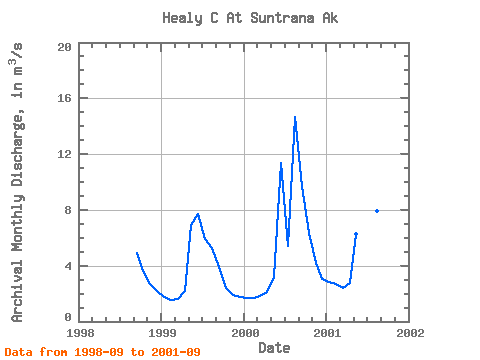
| Year | Jan | Feb | Mar | Apr | May | Jun | Jul | Aug | Sep | Oct | Nov | Dec | Annual | 1998 | 4.88 | 3.61 | 2.66 | 2.21 | 1999 | 1.79 | 1.52 | 1.59 | 2.18 | 6.94 | 7.70 | 5.93 | 5.28 | 3.88 | 2.41 | 1.92 | 1.75 | 3.57 | 2000 | 1.69 | 1.71 | 1.85 | 2.09 | 3.20 | 11.39 | 5.40 | 14.67 | 9.71 | 6.36 | 4.16 | 3.04 | 5.44 | 2001 | 2.81 | 2.69 | 2.43 | 2.76 | 6.25 | 9.57 | 8.02 | 7.92 | 6.26 |
|---|
 Return to R-Arctic Net Home Page