|
|
|||||||||||||||||
| Point ID: 9399 | Downloads | Plots | Site Data | Code: 15904800 |
|
|
|||||||||||||||||
| Download | |
|---|---|
| Site Descriptor Information | Site Time Series Data |
| Link to all available data | |
|
|
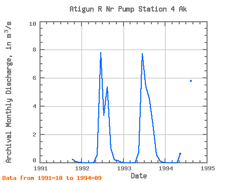
| View: | Statistics | Time Series |
| Units: | mm |
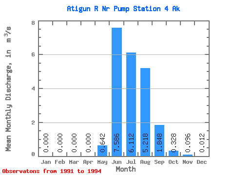
| Statistic | Jan | Feb | Mar | Apr | May | Jun | Jul | Aug | Sep | Oct | Nov | Dec | Annual |
|---|---|---|---|---|---|---|---|---|---|---|---|---|---|
| Mean | 0.00 | 0.00 | 0.00 | 0.00 | 0.64 | 7.59 | 6.11 | 5.22 | 1.85 | 0.33 | 0.10 | 0.01 | 1.67 |
| Standard Deviation | 0.00 | 0.00 | 0.00 | 0.00 | 0.10 | 0.28 | 3.17 | 0.64 | 0.86 | 0.20 | 0.04 | 0.01 | 0.20 |
| Min | 0.00 | 0.00 | 0.00 | 0.00 | 0.54 | 7.27 | 3.37 | 4.52 | 1.00 | 0.18 | 0.05 | 0.01 | 1.53 |
| Max | 0.00 | 0.00 | 0.00 | 0.00 | 0.74 | 7.78 | 9.59 | 5.79 | 2.72 | 0.56 | 0.12 | 0.02 | 1.81 |
| Coefficient of Variation | 0.15 | 0.04 | 0.52 | 0.12 | 0.47 | 0.61 | 0.39 | 0.88 | 0.12 |
| Year | Jan | Feb | Mar | Apr | May | Jun | Jul | Aug | Sep | Oct | Nov | Dec | Annual | 1991 | 0.25 | 0.05 | 0.01 | 1992 | 0.00 | 0.00 | 0.00 | 0.00 | 0.54 | 7.78 | 3.37 | 5.34 | 1.00 | 0.18 | 0.12 | 0.02 | 1.53 | 1993 | 0.00 | 0.00 | 0.00 | 0.00 | 0.74 | 7.71 | 5.38 | 4.52 | 2.72 | 0.56 | 0.11 | 0.01 | 1.81 | 1994 | 0.00 | 0.00 | 0.00 | 0.00 | 0.64 | 7.27 | 9.59 | 5.79 | 1.82 |
|---|
 Return to R-Arctic Net Home Page