|
|
|||||||||||||||||
| Point ID: 9388 | Downloads | Plots | Site Data | Code: 15746983 |
|
|
|||||||||||||||||
| Download | |
|---|---|
| Site Descriptor Information | Site Time Series Data |
| Link to all available data | |
|
|
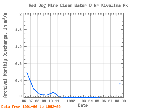
| View: | Statistics | Time Series |
| Units: | mm |
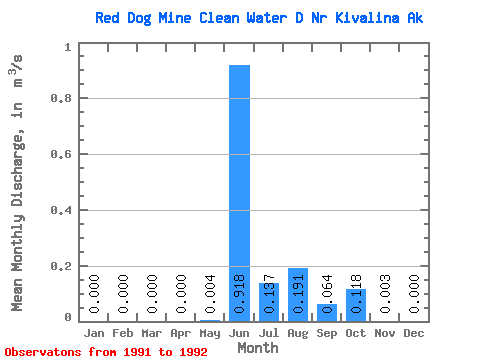
| Statistic | Jan | Feb | Mar | Apr | May | Jun | Jul | Aug | Sep | Oct | Nov | Dec | Annual |
|---|---|---|---|---|---|---|---|---|---|---|---|---|---|
| Mean | 0.00 | 0.00 | 0.00 | 0.00 | 0.00 | 0.92 | 0.14 | 0.19 | 0.06 | 0.12 | 0.00 | 0.00 | |
| Standard Deviation | 0.46 | 0.08 | 0.18 | 0.01 | |||||||||
| Min | 0.00 | 0.00 | 0.00 | 0.00 | 0.00 | 0.59 | 0.08 | 0.07 | 0.05 | 0.12 | 0.00 | 0.00 | |
| Max | 0.00 | 0.00 | 0.00 | 0.00 | 0.00 | 1.25 | 0.19 | 0.32 | 0.07 | 0.12 | 0.00 | 0.00 | |
| Coefficient of Variation | 0.51 | 0.60 | 0.93 | 0.24 |
| Year | Jan | Feb | Mar | Apr | May | Jun | Jul | Aug | Sep | Oct | Nov | Dec | Annual | 1991 | 0.59 | 0.19 | 0.07 | 0.05 | 0.12 | 0.00 | 0.00 | 1992 | 0.00 | 0.00 | 0.00 | 0.00 | 0.00 | 1.25 | 0.08 | 0.32 | 0.07 |
|---|
 Return to R-Arctic Net Home Page